Synergy Positioning Systems
  • Home
  • Products
    • Machine Control
      • Excavator
      • Dozer
      • Grader
      • Paving and Milling
      • Special Applications
      • Accessories
    • GNSS Equipment
      • GNSS Receivers
      • GNSS Antennas
      • Radio Transmitters
    • Total Stations
      • Conventional
      • Robotic
      • Monitoring
    • Lasers and Levels
      • Rotating Lasers
      • Pipe Lasers
      • Line/Cross Lasers
      • Levels
      • Accessories
    • Aerial Mapping Systems
    • Measuring Instruments
      • Structural Crack Monitoring
      • Geotechnical Testers
      • Measuring Wheels
      • Electronic Distance Meters
      • Magnetic Locators
      • Moisture meters
    • Software
      • Field
      • Design & Planning
      • Mapping
      • BIM Software
      • Telematics
    • Field Controllers
    • Topcon Laser Scanning
    • FARO Laser Scanning
      • FARO Scanners
      • Faro Software
    • Mobile Mapping
    • Hydrographic Survey Equipment
      • Single Beam Echo Sounders
      • Unmanned Survey Vessels
      • Jet Ski Survey Watercraft
      • Hydrographic Survey Software
      • PPS Synchronization
      • Tide Gauge
    • Survey Accessories
      • Tripods
      • Prisms and Holders
      • Tribrachs and Adapters
      • Levelling Staves
      • Setout Equipment
    • Lighting Systems
      • Halogen (Filament)
      • LED
      • Metal Halide Lamp
      • Quadro
      • Twinlight
      • Xenon
      • Accessories
  • Skynet RTK
  • News
  • About Us
    • Employment
    • Key Contacts
    • Vision
    • History
    • Case Studies
  • Contact Us
  • Home
  • Products

    Featured Products

    • Topcon SmoothRide Resurfacing
      Topcon
      View Product
    • Topcon X53i Total Station Control
      Topcon
      View Product
    • Topcon LN-100 Robotic
      Topcon
      View Product

    Browse, enquire & hire from our product range below

    • Machine Control
      • Excavator
      • Dozer
      • Grader
      • Paving and Milling
      • Special Applications
      • Accessories
    • GNSS Equipment
      • GNSS Receivers
      • GNSS Antennas
      • Radio Transmitters
    • Total Stations
      • Conventional
      • Robotic
      • Monitoring
    • Lasers and Levels
      • Rotating Lasers
      • Pipe Lasers
      • Line/Cross Lasers
      • Levels
      • Accessories
    • Aerial Mapping Systems
    • Measuring Instruments
      • Structural Crack Monitoring
      • Geotechnical Testers
      • Measuring Wheels
      • Electronic Distance Meters
      • Magnetic Locators
      • Moisture meters
    • Software
      • Field
      • Design & Planning
      • Mapping
      • BIM Software
      • Telematics
    • Field Controllers
    • Topcon Laser Scanning
    • FARO Laser Scanning
      • FARO Scanners
      • Faro Software
    • Mobile Mapping
    • Hydrographic Survey Equipment
      • Single Beam Echo Sounders
      • Unmanned Survey Vessels
      • Jet Ski Survey Watercraft
      • Hydrographic Survey Software
      • PPS Synchronization
      • Tide Gauge
    • Survey Accessories
      • Tripods
      • Prisms and Holders
      • Tribrachs and Adapters
      • Levelling Staves
      • Setout Equipment
    • Lighting Systems
      • Halogen (Filament)
      • LED
      • Metal Halide Lamp
      • Quadro
      • Twinlight
      • Xenon
      • Accessories
  • Skynet RTK
  • News
  • About Us
    • Employment
    • Key Contacts
    • Vision
    • History
    • Case Studies
  • Contact Us
  • 0800 867 266
  • Email Us

Services

  • Asphalt Roads and Surfaces
    • PaveSmart
    • Engineering Surveyors
    • Survey Profilograph & Design
    • Line Marking Survey
    • 360° Pavement Design
    • Synergy Big Sonic Ski
    • Synergy Road Scanning System
    • 3D Paving & Milling Control
  • 3D Laser Scanning
    • What We Provide
    • 3D Laser Scanning Process
    • Sales Support and Training
    • Case Studies

Your enquiry

Thank you. We will get back to you as soon as possible.

  • Hide Form
  • Asphalt Roads and Surfaces
    • Home
    • Services
    • Asphalt Roads and Surfaces

    Asphalt Roads and Surfaces

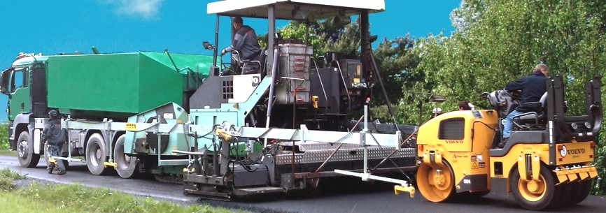
    One of our core services, Synergy Positioning are experts in asphalt paving and milling level control and surveying technologies. From roading, airport runways, sports fields and bridge deck surfacing we offer a complete design, survey and level control solution to all your paving and milling requirements. Using a host of specialist systems including; PaveSmart, Road Scanning, High Speed Survey Profilograph and the latest in Robotic Total Station technology, our experienced survey consultancy team provides complete control of any asphalt surfacing project.

    • PaveSmart

        Synergy’s patented PaveSmart system provides; survey accurate, variable depth, asphalt paving and milling level control. Used on a range of high profile projects throughout; Australia, New Zealand and the Asia Pacific region; the ...

      Read More
    • Engineering Surveyors

            While Synergy Positioning is well regarded within the industry for its work on road surface profiling and design, we’re also very well known for tackling projects off the main highways, ...

      Read More
    • Survey Profilograph & Design

      Synergy’s Survey Profilograph vehicle provides an accurate high speed representation of the longitudinal and cross sectional change in grade for pavements of any type. Not only is the system is perfect for checking the geometric shape of an ...

      Read More
    • Line Marking Survey

      Reinstating lane marking after surface rehabilitation work has been completed has traditionally been a long process, involving extended closure times. Whereas previously lane markings would need to be mapped with measuring tape and recorded on ...

      Read More
    • 360° Pavement Design

      Synergy Positioning also offers a full in-house CAD design service for improving existing road and pavement surfaces, utilising either our survey profilograph system or one of our team of consultants to collect applicable survey data. With our ...

      Read More
    • Synergy Big Sonic Ski

      To achieve absolute smoothness in asphalt paving for certain highway applications, Synergy Positioning can also supply for hire the Big Sonic Ski Averaging Beam; this time fitted with a series of ultrasonic sensors which detect ground height. The ...

      Read More
    • Synergy Road Scanning System

      Rather than rely on a large metal Averaging Beam, we affix a laser to the asphalt paver’s screed. This scans the road surface with multiple beams of light at every degree; measuring the return and calculating the height as it goes. The system ...

      Read More
    • 3D Paving & Milling Control

      Synergy Service Offerings We possess the tried and trusted technology to achieve absolute accuracy and consistency in paving and milling control. But it also comes down to operator experience and, after many years in the industry, Synergy ...

      Read More
Synergy Positioning Systems A Synergy Group Company

Follow us on Twitter

Follow @SynergyPosition

Join mailing list for news & Updates

  • Home
  • Products
    • Machine Control
    • GNSS Equipment
    • Total Stations
    • Lasers and Levels
    • Aerial Mapping Systems
    • Measuring Instruments
    • Software
    • Field Controllers
    • Topcon Laser Scanning
    • FARO Laser Scanning
    • Mobile Mapping
    • Hydrographic Survey Equipment
    • Survey Accessories
    • Lighting Systems
  • Skynet RTK
  • News
  • About Us
    • Employment
    • Key Contacts
    • Vision
    • History
    • Case Studies
  • Contact Us
    • Auckland
    • Hamilton
    • Wellington
    • Christchurch
    • Support
© 2025 Synergy Positioning Systems Ltd. All rights reserved. Website Design by 96black