Synergy Positioning Systems
  • Home
  • Products
    • Machine Control
      • Excavator
      • Dozer
      • Grader
      • Paving and Milling
      • Special Applications
      • Accessories
    • GNSS Equipment
      • GNSS Receivers
      • GNSS Antennas
      • Radio Transmitters
    • Total Stations
      • Conventional
      • Robotic
      • Monitoring
    • Lasers and Levels
      • Rotating Lasers
      • Pipe Lasers
      • Line/Cross Lasers
      • Levels
      • Accessories
    • Aerial Mapping Systems
    • Measuring Instruments
      • Structural Crack Monitoring
      • Geotechnical Testers
      • Measuring Wheels
      • Electronic Distance Meters
      • Magnetic Locators
      • Moisture meters
    • Software
      • Field
      • Design & Planning
      • Mapping
      • BIM Software
      • Telematics
    • Field Controllers
    • Topcon Laser Scanning
    • FARO Laser Scanning
      • FARO Scanners
      • Faro Software
    • Mobile Mapping
    • Hydrographic Survey Equipment
      • Single Beam Echo Sounders
      • Unmanned Survey Vessels
      • Jet Ski Survey Watercraft
      • Hydrographic Survey Software
      • PPS Synchronization
      • Tide Gauge
    • Survey Accessories
      • Tripods
      • Prisms and Holders
      • Tribrachs and Adapters
      • Levelling Staves
      • Setout Equipment
    • Lighting Systems
      • Halogen (Filament)
      • LED
      • Metal Halide Lamp
      • Quadro
      • Twinlight
      • Xenon
      • Accessories
  • Skynet RTK
  • News
  • About Us
    • Employment
    • Key Contacts
    • Vision
    • History
    • Case Studies
  • Contact Us
  • Home
  • Products

    Featured Products

    • Topcon SmoothRide Resurfacing
      Topcon
      View Product
    • Topcon LN-100 Robotic
      Topcon
      View Product
    • Topcon X53i Total Station Control
      Topcon
      View Product

    Browse, enquire & hire from our product range below

    • Machine Control
      • Excavator
      • Dozer
      • Grader
      • Paving and Milling
      • Special Applications
      • Accessories
    • GNSS Equipment
      • GNSS Receivers
      • GNSS Antennas
      • Radio Transmitters
    • Total Stations
      • Conventional
      • Robotic
      • Monitoring
    • Lasers and Levels
      • Rotating Lasers
      • Pipe Lasers
      • Line/Cross Lasers
      • Levels
      • Accessories
    • Aerial Mapping Systems
    • Measuring Instruments
      • Structural Crack Monitoring
      • Geotechnical Testers
      • Measuring Wheels
      • Electronic Distance Meters
      • Magnetic Locators
      • Moisture meters
    • Software
      • Field
      • Design & Planning
      • Mapping
      • BIM Software
      • Telematics
    • Field Controllers
    • Topcon Laser Scanning
    • FARO Laser Scanning
      • FARO Scanners
      • Faro Software
    • Mobile Mapping
    • Hydrographic Survey Equipment
      • Single Beam Echo Sounders
      • Unmanned Survey Vessels
      • Jet Ski Survey Watercraft
      • Hydrographic Survey Software
      • PPS Synchronization
      • Tide Gauge
    • Survey Accessories
      • Tripods
      • Prisms and Holders
      • Tribrachs and Adapters
      • Levelling Staves
      • Setout Equipment
    • Lighting Systems
      • Halogen (Filament)
      • LED
      • Metal Halide Lamp
      • Quadro
      • Twinlight
      • Xenon
      • Accessories
  • Skynet RTK
  • News
  • About Us
    • Employment
    • Key Contacts
    • Vision
    • History
    • Case Studies
  • Contact Us
  • 0800 867 266
  • Email Us

Products

  • Machine Control
    • Excavator
    • Dozer
    • Grader
    • Paving and Milling
    • Special Applications
    • Accessories
  • GNSS Equipment
  • Total Stations
  • Lasers and Levels
  • Aerial Mapping Systems
  • Measuring Instruments
  • Software
  • Field Controllers
  • Topcon Laser Scanning
  • FARO Laser Scanning
  • Mobile Mapping
  • Hydrographic Survey Equipment
  • Survey Accessories
  • Lighting Systems

Your enquiry

Thank you. We will get back to you as soon as possible.

  • Hide Form

Your rental enquiry

Thank you. We will get back to you as soon as possible.

  • Hide Form
  • Topcon X53i LPS Robotic
  • Home
  • Products
  • Machine Control
  • Excavator
  • Topcon X53i Total Station Control
* Please note all prices exclude GST

Topcon X53i Total Station Control

Topcon
Enquire about this product Rent this product

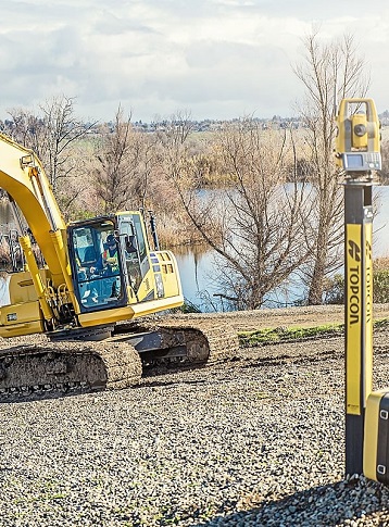
Topcon X53i LPS Robotic – Modernize Your Excavating

Expand your excavating capabilities with the innovative i53 LPS system. Using our powerful PS robotic total station, your excavator seamlessly receives position information using LongLink (Bluetooth) data to accurately depict your buckets position anywhere on the jobsite. No matter if you’re working underground, in heavy tree areas, or in the middle of an open field.

The system uses tough tilt sensors, a versatile receiver box, a graphical control box, and an IMU to deliver limitless excavating opportunities.

  • Durable IP69K rated tilt sensors
  • Powerful LongLink (Bluetooth) technology
  • Integrated LED light bars and audible alarm grade guidance
  • Inertial Measurement Unit (IMU) stability – bucket positioning
  • PowerTrack TM Tracking Technology
  • Single setup GNSS and LPS configurations

3D Control Under Any Condition

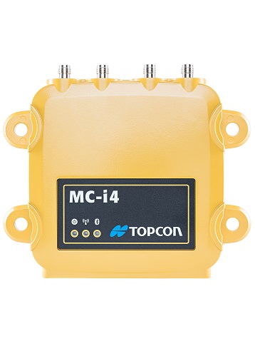
Stay on grade at every critical moment. The i53 LPS is configurable for difficult jobs that have constant GNSS coverage. The system’s MC-i4 GNSS receiver is the central hub for LongLink communication while using PS robotic totals station control, and your gateway to receiving GNSS signals in a single unit. With both LPS and GNSS 3D control available on one system - you increase your workload and decide which system suits each job the best.
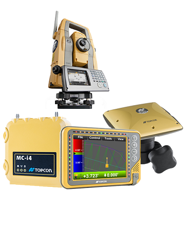
  • Topcon X53i Total Station Control
  • Topcon X53i Total Station Control
  • Topcon X53i Total Station Control
  • Topcon X53i Total Station Control
  • Topcon X53i Total Station Control
  • Topcon X53i Total Station Control
  • Topcon X53i Total Station Control
Enquire about this product Rent this product
  • Technical Specifications
  • Downloads
  • Rental

GX-55 Control Box

  • Supply Voltage: 9 to 32 VDC
  • Ports: 2x USB, Ethernet, RS-232
  • Ports (continued...): 2x CANBus, 2x Digital inputs
  • Display: 640x480 Color VGA, enhanced
  • Display (continued...): brightness with analog touchscreen
  • Operating System: Windows® Compact 7
  • Operating Temp: -40°C to 70°C
  • Weight: 1.26 kg with backbpack
  • Weight (continued...): 1 kg without backpack

MC-i4 Receiver

  • Supply Voltage: 9 to 32 VDC
  • GNSS: Single or Dual
  • Ports: RS232 RS232/RS485
  • Ports (continued...): 10/100 Ethernet
  • Ports (continued...): CAN J1939 CAN J1939/CANOPEN
  • Connectors: Deutsch DTM06 12 pin
  • Connectors (continued...): Deutsch DTM06 12 pin
  • Connectors (continued...): RP-TNC (cellular radio)
  • Connectors (continued...): RP TNC (LongLink, or Wi-Fi, or
  • Connectors (continued...): UHF radio (optional))
  • Connectors (continued...): 2x TNC for GNSS (optional)
  • Shock: 25 g, 11 ms, any axis
  • Weight: 1 kg
  • Dust/Water Rating: IP67

TS-i3 Sensor

  • Supply Voltage: 10 to 30 VDC
  • Connectors: M12
  • Resolution: 0.01º
  • Accuracy: 0.1º
  • Housing: Cast aluminum, black
  • Housing (continued...): powder coated surface
  • Dust/Water Rating: IP68, IP69K

Product Downloads Section

  • Topcon Synergy X53i LPS Robotic 3D Excavator System Brochure 581 KB pdf
  • Topcon Synergy X53i Brochure 390 KB pdf
  • Topcon Synergy 3DMC Reference Guide 6 MB pdf
  • Topcon Synergy 3DMC User Manual 4 MB pdf
  • Topcon Synergy X53i Installation and Calibration Manual 7 MB pdf

Topcon X53i LPS Robotic

Please contact us for more details on product rental.

Free Call: 0800-867-266
Phone: +64-9-476-5151
Email: info@synergypositioning.co.nz
 

Synergy Positioning Systems A Synergy Group Company

Follow us on Twitter

Follow @SynergyPosition

Join mailing list for news & Updates

  • Home
  • Products
    • Machine Control
    • GNSS Equipment
    • Total Stations
    • Lasers and Levels
    • Aerial Mapping Systems
    • Measuring Instruments
    • Software
    • Field Controllers
    • Topcon Laser Scanning
    • FARO Laser Scanning
    • Mobile Mapping
    • Hydrographic Survey Equipment
    • Survey Accessories
    • Lighting Systems
  • Skynet RTK
  • News
  • About Us
    • Employment
    • Key Contacts
    • Vision
    • History
    • Case Studies
  • Contact Us
© 2025 Synergy Positioning Systems Ltd. All rights reserved. Website Design by 96black