
About Us
Giving the Project Wings
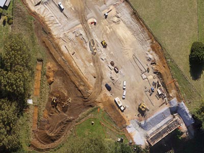
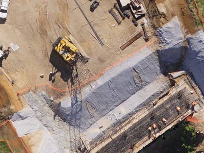
Time is constantly of the essence on the large scale Waikato Expressway project. For HEB Construction, the need to survey large corridors of terrain regularly led them to utilise the services of Synergy Positioning Systems' aerial survey consultancy team.
With the infrastructure and manpower costs involved in surveying 16 linear kilometres of road on the ground, HEB Construction looked to the skies recently to solve a regular issue.
Originally ground survey teams were collecting large numbers of spot height data to generate a terrain model, which could in turn be used to calculate volume changes over different parts of the project on a month-by-month basis.
“Prior to implementing aerial surveys, the process was a lot slower,” says HEB contractors representative Gary Budden. “Naturally with a ground survey team working in the field there is the potential for a heightened element of risk, meaning mobile plant would need to be inactive over a period of time.”
“Then at the back-end, data accumulation was slow for the survey team. The introduction of aerial surveying really sped things up though, as well as taking staff out of the work zone; the unobtrusiveness of this process to the wider project can’t be overstated.”
HEB senior surveyor Nigel Neame is working with Synergy Positioning Systems’ UAV (Unmanned Aerial Vehicle) survey consultancy with a view to increase working efficiency along the busy Tamahere to Cambridge section of the Waikato Expressway project, after seeing the benefits of aerial survey work first hand overseas.
“I’d had some prior experience with UAVs in the mines in Australia; mainly from a data delivery stand-point, but the operational efficiencies the technology allows for are fantastic too,” says Gary. “The Synergy team sets up in a paddock nearby, takes off and flies their passes and then lands again all at this remote location; we don’t have to deviate from our day’s plan anywhere along the work corridor at all.”
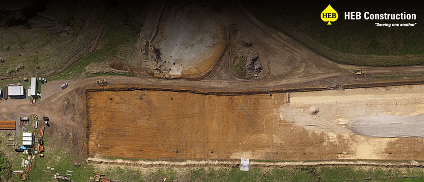
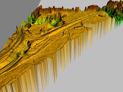
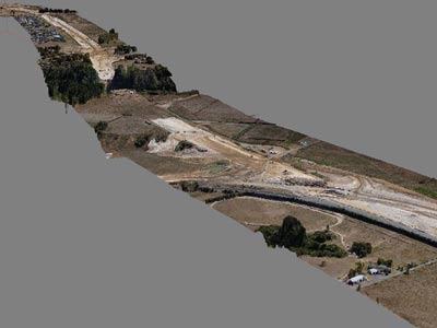
Providing orthophotography and 1m grid TIN Digital Surface Model (DSM) data for HEB Construction to import into CAD, Synergy aims to capture the required data during two consecutive flights across the project area once a month.
Even with 16 lineal kilometres of terrain to capture, with favourable weather the entire process is completed within a couple of hours, as opposed to the days a field survey team might take to cover the same distance.
“The speed with which we can then review captured data is crucial,” continues Nigel. “Because we can see the whole picture very quickly, the survey gives us a valuable snapshot of the project at a specific time. There’s no discrepancy with the data and we can see volume change information over different parts of the project, which helps us with our billing processes among other things.”
Gallery
As with all such UAV mapping and survey projects, Synergy Positioning System’s comprehensive service provides HEB Construction with an end-to-end service; assessing survey requirements, planning flight missions, operating the UAVs and obtaining and delivering required data and back-up support to the client quickly and efficiently.
Thus far Synergy’s trained pilots, who boast significant flying and data collection experience, have completed two full surveys for the civil construction entity with ongoing flight missions planned for the months ahead.
While there are clear operational benefits to being up in the air, at the same time the technology allows costs to remain firmly grounded, with clear wins in terms of required staff resources and commercial costs between utilising the UAV service versus employing a team of five or six surveyors in the field.
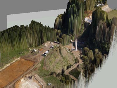
“Synergy’s fly-over work has other useful spin-offs for us too,” adds Nigel. “Because we have accurate aerial imagery on hand, this allows us to illustrate facets of the wider project to a variety of stakeholders, some of whom might not be used to looking at technical interpretations.
“The orthophotography images the UAV takes help those stakeholders better understand landscape and project features at a glance, as well as illustrate overall project progress. This speeds up conversations and actions at a managerial level.”
With constricted, multi-level deadlines necessitating every working hour on this vast site is utilised as efficiently as possible, taking to the air has certainly helped HEB Construction maintain their project goals on the ground.
For more information on UAV services and applications, click here.
Back to all case studiesProject Snapshot
Location: Waikato Region, New Zealand
Involved
![]()
HEB Construction

Synergy Positioning Systems
Products and Services used
Synergy Positioning Systems’ UAV
Click Here for More Info
More information
HEB Construction
Waikato Expressway Project
Related Case Studies
-

UAV’s Changing The Face Of Topographical Surveying
While Unmanned Aerial Vehicles (UAVs) have become more commonplace in recent years, many industries are still only just beginning to tap into what the technology can be utilised for and what project planning goals UAVs can help achieve....
Read More -
Dines Group maps the future of Pokeno
While the applications for aerial survey data gathered via specialised Unmanned Aerial Vehicles (UAVs) continue to evolve and grow, often the most effective uses for detailed aerial map information are also the most obvious....
Read More