
About Us
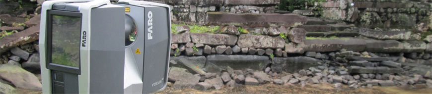
Well-Connected Waterview Alliance / FARO Focus3D
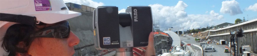
Surveyor Mike Cutfield of Fletcher Construction has been utilising a FARO Focus3D high speed laser scanner for monitoring work around the tunnel portals on the enormous Waterview Connection ‘Roads of National Significance’ project in Auckland.
Absolutely nothing about the $1.4b Waterview Connection project in Auckland is small, yet as it turns out Fletcher Construction surveyor Mike Cutfield saw the size factor as a key benefit to using FARO’s Focus3D high speed 3D laser scanner.
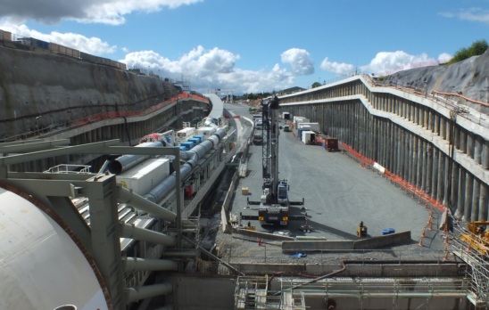
Mike is based at the southern portal of what will, by its completion date in 2017, be the Waterview Tunnel, stretching for 2.4km under Auckland’s western suburbs as part of the 5km, six-lane motorway extension linking State Highways 16 and 20.
The tunnel is very much the centrepiece of this Roads of National Significance (RoNS) project and will be the largest constructed to date in New Zealand and Australia.
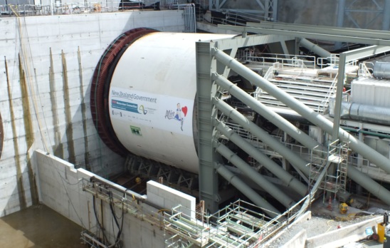
To do the tunnelling, the Well-Connected Waterview Alliance (consisting of the New Zealand Transport Agency, Fletcher Construction, McDonnell Dowell, Parsons Brinckerhoff, Beca, Tonkin & Taylor, Obayashi, Wilson Tunnelling and SICE) is using a 14m diameter custom-built Earth Pressure Balance Machine (EPBM) called ‘Alice’; an innocuous name for the 10th biggest tunnel boring machine ever built.
‘Alice’ will be tasked with boring twin road tunnels side-by-side, travelling as deep as 45m below the surface.
As Mike Cutfield explains though, among the giant machinery and headline-grabbing statistics of this enormous project, the lightweight and portable FARO Focus3D laser scanner has an integral part to play; ensuring tunnel construction work runs smoothly and, most importantly, safely.
“We’re primarily using the FARO laser scanner for monitoring the trenches where the portal to the tunnel is, essentially to check for structural movement,” he says.
“Alice is starting the bore down here at the southern end of the tunnel and we’re not expecting too much movement; it’s all basalt rock here, so reasonably tough. The northern portal at Waterview is a different story though.
“The soils there are alluvial, so a lot softer. They’ve started to dig out but are using diaphragm walls to sheer everything up. They’re actually expecting the d-walls to deflect by up to 80mm each way during these initial stages. That’s where the laser scanner will be crucial again, because we need to monitor those deflection percentages to make sure everything remains structurally sound.”
Synergy Positioning supplied Mike with special checkerboard targets, which he has subsequently had made into all-weather corflute signs. The two centre-points of the checkerboards act as reference points for the scanner, which has a range of up to 120m.
“The FARO system comes with reference spheres as well, which the scanner recognises in the same way as the checkerboards. For me though, what with the semi-permanent set-up we have at the portal, the checkerboards work better as they are attached to concrete facings along the sides of the trench meaning we don’t have to bring them on-site each time we complete monitoring work.
“Also the checkerboards are getting picked up by the scanner without any issues at about a 50m distance. The spheres need to be closer to the scanner to register which isn’t always possible with the access restrictions of such a large and busy worksite,” says Mike.
Gallery
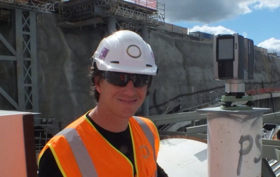
While the FARO Focus3D comes with a tripod, the semi-permanent set up Mike has at the southern portal extends to pillars set above the portal, where the scanner can be attached each time monitoring work is required.
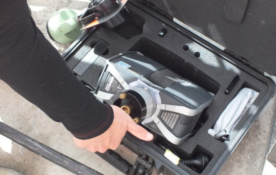
The end result is that Mike can leave the site office with nothing more than the compact FARO laser scanner in its hard-shell briefcase to head to the tunnel’s entrance.
The data Mike collects can then be downloaded via SD card into the Scene software that comes with the FARO Focus3D. The three dimensional picture Mike gets of all elevations of the portal can then be ‘sliced’ at certain levels and compared against data from the previous week’s monitoring programme.
Because the FARO Focus3D takes photographs as it scans, colour can be added to the scan to create an accurate, hyper-realistic 3D image of the environment. It’s clever tech, but for Mike, there were a couple of simple factors that saw him championing the purchase of the FARO Focus3D.
“Basically the portability and the price were what sold me on this. When I first saw laser scanners while I was working as a surveyor in the UK seven years ago, they cost around £200,000 and had to be carted around in a van, they were so big.
“Seven years later I have a high-speed 3D laser scanner that can scan complex structures in minutes, and it fits in a briefcase – that’s incredible.”
Additionally Mike says the cost of the FARO Focus3D was a major selling-point, giving him the ability to capture and analyse accurate, detailed data crucial to the wider Waterview project at a fraction of the cost of completing the same surface surveying work manually.
“It’s really affordable technology,” he says.
Mike was also impressed with the Synergy Positioning technical staff that came out on-site to help set the system up for the first time, running through its basic operational procedures and essentially being on-call while Mike learnt how to get the best out of the laser scanner.
Back to all case studies“The Synergy guys let me use the FARO pretty intensively for a few days to get used to it, and while it’s an intuitive system and I’m using it week in, week out now, I know if I have any issues they’re just a phone call away.”
Project Snapshot
Location:Auckland, New Zealand
Involved
![]()
Fletcher Construction

Synergy Positioning Systems
Products used
FARO Focus3D
More information
Fletcher Construction
Related Case Studies
-
Technipipe diversifies its activities using a FARO Laser Scanner
Technipipe, a specialist in pipeline engineering, inspection and maintenance services, has won an international reputation for itself in the area of petroleum engineering. Its clients include many of the big names in the industry. Since they wanted ...
Read More -
Otago University Nan Madol Runis
Faro Focus 3D Laser Scanner used on Otago School of Survey study of the Nan Madol ruins Micronesia for Humanities division of Otago University and National Geographic....
Read More