
About Us

Synergy Australia CAD Packages
On both sides of the Tasman, Synergy Positioning Systems offers a full in-house CAD design service for improving existing road and pavement surfaces.
Synergy Positioning Systems’ consultancy team uses its comprehensive CAD packages in order to redesign the entire shape of roads, access ways or concrete bridge decks to full geometric survey criteria.
In Australia, Synergy Positioning Systems’ engineering surveyor Jason Carroll and his team have been engaged on several projects where they were required to take survey data and establish the parameters of the restoration work required; milling map, volume of asphalt needed, NAASRA/IRI targets, crossfall data and other requirements ahead of the remedial work taking place.
“The programs that we are using are 12d Ver11 and Terramodel Ver 10.61,” says Jason.
“We use 12d for our data calculations, design and file conversions of data into other formats for use in other programs such as our field controllers.
“Terramodel is being used to generate 3D modelling, volume and area calculations, design models, cross section information and the drafting of plans.”
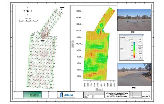
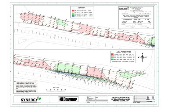
A recent project Jason worked on was the asphalt surface at the Mt. Cotton Driver Training Facility in Queensland; an environment where high speed performance driving requires high-performing pavement.
“This surface was surveyed using a small grid for the purpose of finding low and high spots with minimal tolerances. Synergy was able to generate an isopach over the surface to determine depths to a design triangulated surface.
“This was beneficial to our client as a visual on site and it allowed decisions to be made quickly on construction techniques.”
Synergy is using Terramodel’s 3D application to show existing data, design data or any surface, so any queries in design can be easily detected.
Gallery
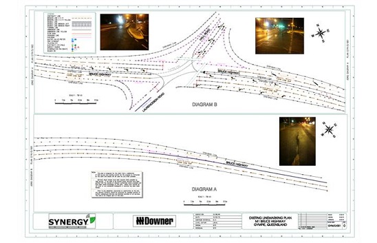
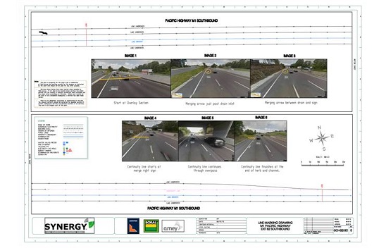
Another common request is the surveying of existing line markings; often requested before construction begins for design purposes or line replacement work. Synergy is able to produce line marking plans for the use of the client, line markers or the surveyor in the field.
“Sometimes the data is unclear or inaccurate to create a line-marking design,” says Jason.
“However we are able to use imagery from Google or Nearmap to confirm line marking. We can also provide clients with KML files, overlaying our data onto imagery supplied by the same imagery from Google Earth and Nearmap.”
Line-marking plans can also be used as as-constructed plans and can be attached to client data. Jason says that this data can be forwarded in any format our client requests, including pdf, dwg, dxf and 12da.
Jason also says that the output of electronic data in the asphalt industry is beginning to play a larger part in calculating costings and charging for Synergy’s clients.
“The ability to show such accurate data in plan and electronic form is invaluable to our clients at the completion of a contract.
“Synergy has the ability to maintain up-to-date electronic projects, helping our clients with any questions during the construction period.”
When the new surface design data is taken and entered into one of Synergy Positioning’s machine control systems on the contractor’s milling machine or asphalt paver, this allows for accurate surface cutting or asphalt laying to proceed based entirely on the data initially mapped, resulting in a full 360 degree design experience for the client.
Back to all case studiesProject Snapshot
Location: Queensland, Australia
Involved

Synergy Positioning Systems
Products and Services used
Asphalt Roads and Surfaces
Click Here for More Info
Related Case Studies
-
Downer engages Synergys’ PaveSmart Grade Control
Downer recently engaged Synergy Positioning Systems’ survey consultancy service and PaveSmart grade control system to ensure time and cost savings on resurfacing a lengthy section of Christchurch arterial road....
Read More -
Synergy heads for high ground on Toowoomba Range Remediation
Using ultrasonic technology and the advanced technical support of Synergy Positioning Systems’ survey and paving consultancy team, Boral Asphalt Toowoomba was recently able to successfully complete a challenging paving assignment on a high ...
Read More