
Products
- Machine Control
- GNSS Equipment
- Total Stations
- Lasers and Levels
- Aerial Mapping Systems
- Measuring Instruments
- Software
- Field Controllers
- Topcon Laser Scanning
- FARO Laser Scanning
- Mobile Mapping
- Hydrographic Survey Equipment
- Survey Accessories
- Lighting Systems
Your enquiry
Your rental enquiry
- Home
- Products
- Machine Control
- Topcon X-53 2D Control
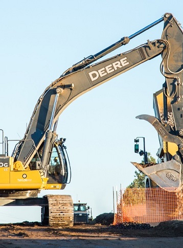
Topcon X-53 2D Control
Topcon X52 - 2D Excavation Essentials
A streamlined and modern excavation system that gets you to grade as a cost effective 2D solution.
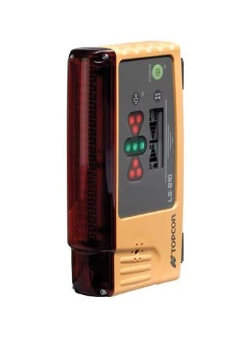
Our ruggedized LS-B10W laser receiver combined with compact TS-1 tilt sensors allow you to stay on grade without having to ever re-string. To complete each task, the GX-55 control box actively guides your bucket where it needs to be and gives you an experience that was designed for your excavating skills.
When future projects dictate GNSS location and precision, the X-52 system is easily upgraded to 3D.
- Increase safety by removing grade checker from the trench
- Work from an existing elevation reference or laser
- Easily upgradable to full 3D GNSS
- Create, cut, and check complex designs from the cab
- Easy-to-see cut/fill indicators
Become One With Your Work
Today's demand for a safe site is easily answered by incorporating our excavator systems to your daily tasks. We keep a man out of the hole and optimize digging to save you money and keep schedules on track. From digging underwater to blind cuts, we’ve got you covered with our bright LED grade indicators, graphical representation of the bucket's position, and loud audible tones.
The X-52 excavator system gives you the flexibility to use a wide array of references to work from: existing surface, a hub, a previous cut, or a rotating laser. It's as simple as choosing your reference and entering a cut and/or slope depth.
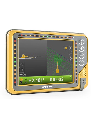
GX-55 Specifications
- Supply Voltage: 9 to 32 VDC
- Ports: 2x USB, Ethernet, RS-232,
- Ports (continued...): 2x CANBus, 2x Digital inputs
- Display Panel: 640x480 Color VGA, enhanced
- Display Panel (continued...): brightness with analog touchscreen
- Operating System: Windows® CE
- Operating Temp: -40°C to 70°C
- Weight: 1.26 kg with backbpack
- Weight (continued...): 1 kg without backpack
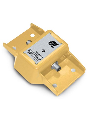
TS-1 Specifications
- Supply Voltage: 10 to 30 VDC
- Resolution: .01 Degree
- Protocol: CAN-Open
- Sensor: Solid state, 3-axis, 360
- Housing: Powder-coated aluminum
- Dust/Humidity: IP67
LS-B10W Specifications
- Detection Range: Vertical: 120mm Horizontal: 270º
- On-Grade Zone: 2 mm, 6 mm, 12 mm, 30mm
- Ports: CAN / Wireless
- Dimensions: 115 x 40 x 180 mm
Product Downloads Section
Topcon X52
Please contact us for more details on product rental.
Free Call: 0800-867-266
Phone: +64-9-476-5151
Email: info@synergypositioning.co.nz