
Products
- Machine Control
- GNSS Equipment
- Total Stations
- Lasers and Levels
- Aerial Mapping Systems
- Measuring Instruments
- Software
- Field Controllers
- Topcon Laser Scanning
- FARO Laser Scanning
- Mobile Mapping
- Hydrographic Survey Equipment
- Survey Accessories
- Lighting Systems
Your enquiry
Your rental enquiry

- Home
- Products
- Machine Control
- Topcon 3D GPS Systems for Trencher
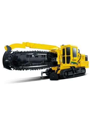
Topcon 3D GPS Systems for Trencher
Topcon's 3D Trencher designed for digging trenches with the use of 3D technology. Eliminating the need to reference and check alignments by using GPS and TS-1 Tilt Sensors to control the blade the 3D Trencher makes digging trenches easy.
Features & Benefits:
- Avoid trenching too deep.
- More accurate alignment of excavation.
- Fast and easy to use.
- Same user interface for all Topcon's 3DMC.
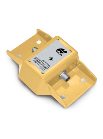
TS-1 Tilt Sensor:
- Environmentally sealed.
- No moving parts.
- 3-axis, 360° sensor.
- CAN port interface.
- 0.01 degree resolution.
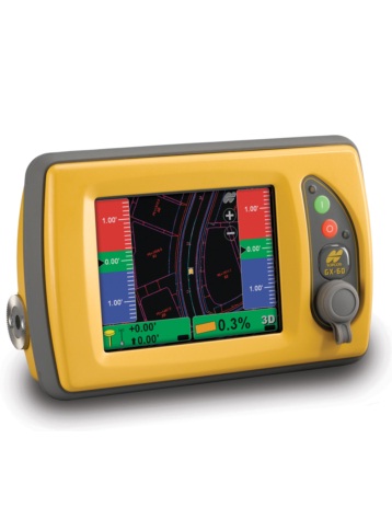
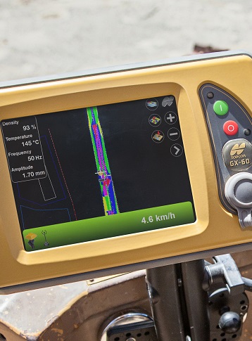
GX-60 Control Box:
- High-resolution, bright, color, touch screen display.
- Bluetooth, Ethernet, and USB communication.
- Adjustable side or rear mounting options.
- Quick-disconnect connectors.
- Internal back-up battery pack.
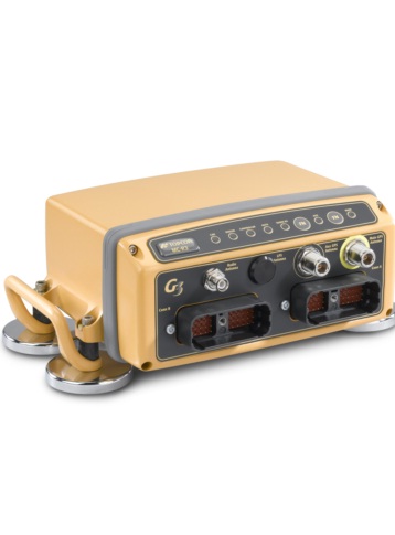
MC-R3 GNSS Receiver:
- G3 Tracking technology.
- Network capable receiver with GSM / CDMA.
- UHF & Spread Spectrum radio options.
- LED status indicators.
- Advance Multipath Reduction (AMR).
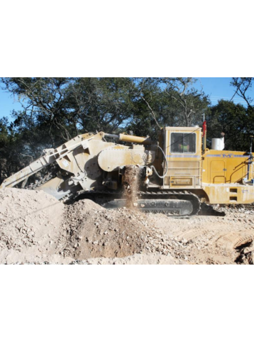
Avoid Trenching Too Deep
By utilizing the TS-1 Sensors for controlling the arm the operator can avoid trenching to deep or too shallow. The TS-1 sensor work with the MC-R3 and GX-60 Control box to update the teeth position real-time. Knowing the depth at all times gives the operator confidence in the trench being constructed by plan without requiring someone in the trench constantly checking grade.
More Accurate Alignment of Excavation
Using the TS-1 and GNSS position from the MC-R3 the alignment of the trench is more accurate than conventional methods. This technology also promotes a safer work environment by eliminating the need to have someone in the trench checking the position.
Fast and Easy to Use
Easy to install, easy to setup and ready to work in minutes! The ease of use and ease of setup eliminate down time and keep the operator working. The 3D interface allows the machine to move around the job site without requiring him to wait for grade stakes or alignment files. Based on the same 3D job files as other Topcon 3D machines the operator has a constant reference to where he is on the site.
Same User Interface for all Topcon's 3DMC
As with all Topcon 3D systems the operator interface is intuitive and easy to use. The same 3DMC interface as all other Topcon 3D systems powers the 3D Trencher. A seamless transition form other 3D machines gives the operator confidence in his daily tasks on any machine.

MC-R3 Electrical Specifications
- Supply Voltage: 10-30 VDC
- Supply Current: 3A typical operating current
- Emmissions: Applicable regulation: EN55022
- Immunity: Applicable regulation: EN55024
- Output Power: 10A max for sensors
- Ports: 2 ea. CAN ports 2 ea. Ethernet ports
MC-R3 Physical Specifications
- Housing: Powder-coated, cast aluminum
- Connectors: 2 ea. DRC23-40P Deutsch connector
- Switches: Logic control: Hi = On, Low = Off
- LEDs: CAN, Sensor, Controller, Radio Modem
- Cooling: Internal Fan
- Weight: 7.5 lbs
MC-R3 Environmental Specifications
- Operating Temperature: -20°C to +60°C
- Ingress Protection: IP-66
- Shock Rating: 50G 11ms 1/2 sine wave each axis
- Salt Spray Test: MIL-STD 810F
- Vibration Rating: 10-400Hz sweep 5G RMS
TS-1 Tilt Sensor Electrical Specifications
- Resolution: 0.01 Degree
- Protocol: CAN-Open
- Supply Voltage: 10-30 VDC
TS-1 Tilt Sensor Physical Specifications
- Sensor: Solid state, 3-axis, 360°
- Housing: Powder-coated aluminum
- Connectors: 2 ea. M12
- Weight: 1.7 lbs.
TS-1 Tilt Sensor Environmental Specifications
- Operating Temperature: -20°C to +60°C
- Ingress Protection: IP67
9169 ( GX-60 ) Electrical Specifications
- Supply Voltage: 10-30VDC
- Supply Current: 3A Typical operating current
- Switched Output Power: 5A Sensor/Conditioned O/P power
- Ports: USB (2), RS-485, RS-232, CAN(2)
9169 ( GX-60 ) Physical Specifications
- Display Panel: 640x480 Color VGA
- Housing: Cast aluminum
- Audio: 1ea environmentally sealed speaker
- Switches: 2 ea momentary pushbutton
- Connectors: 2 ea 19 socket MIL-C-5015
- Cooling: 1ea internal processor fan
- Weight: 6 lbs.
9169 ( GX-60 ) Environmental Specifications
- Operating Temperature: -20°C to +60°C
- Humidity: Mil Std 810D, method 506
- Shock Rating: 50G 11ms sine wave each axis
- Vibration Rating: 10-400Hz sweep 5G, 1 oct/min
- Salt Fog Test: 48 Hours (ASTM B117-97)
MAGNET Office Software Product Specifications
- Operating System: Microsoft Windows XP,Vista, 7 & 8
- Processor Speed: 2GHz Core2 processor or higher
- RAM: 2GB RAM
- Memory: 512MB minimum (1.0GB recommended)
- Ports: USB2 port for USB key
- Computer Resolution: 1280x1024 display resolution
Product Downloads Section
Topcon 3D GPS Systems for Trencher
Please contact us for more details on product rental.
Free Call: 0800-867-266
Phone: +64-9-476-5151
Email: info@synergypositioning.co.nz