
Products
- Machine Control
- GNSS Equipment
- Total Stations
- Lasers and Levels
- Aerial Mapping Systems
- Measuring Instruments
- Software
- Field Controllers
- Topcon Laser Scanning
- FARO Laser Scanning
- Mobile Mapping
- Hydrographic Survey Equipment
- Survey Accessories
- Lighting Systems
Your enquiry
Your rental enquiry

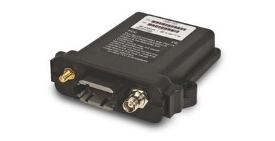
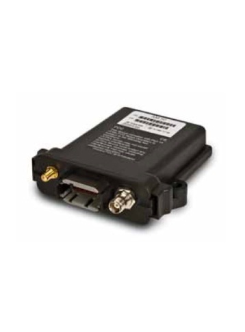
Topcon AM50
Telematic SolutionThe AM50 (Asset Manager) is a complete solution for GPS survey and fleet management. CAN Bus functionality provides full logging of machine parameters. Standard Features:
The AM50 offers complete localization features and data logger capabilities. Each datum is stored with a UTC timestamp. The model's powerful on-board processor and significant memory allows up to 18 MB logging. Communication failure? Not a problem. If the GPRS connection is not available, the device collects and stores your data then forwards it when the network is available. The AM50’s internal battery allows the device to work when your machine or vehicle is off. The device can be configured to send an alarm if a motion is detected or the device may be awakened when a defined time interval has elapsed and send a message with the position to you. Geofence users can be notified via text message (SMS) and/or email whenever a machine or vehicle leaves a geofenced area or zone. And once you know your machine has left, it’s easy to track and recover. NMEA input from precision GPS is available through the serial port or CAN Bus. The CAN Bus works with the standard J1939 protocol. By taking advantage of Tierra’s full remote machine control using GSM and GPRS technologies managing your remote assets has never been easier. The Tierra solution ensures that you have clear visibility to all of your remote assets anywhere in the world 24/7! |
|
|


General
- Microprocessor: ARM7 LPC2378
Memory
- RAM: 58 KB
- Flash NAND: 128 MB
- External RAM: 128 KB
Ports & Connectors
- Serial Port: RS232
- CAN Bus: Lines
- Connector: Deutsch 12-pin GPS = SMA & GPRS = TNC
- Real Time Clock: Yes
- GSM/GPRS Modem : Quad Operating Bands
- Antennas: GSM/GPRS & GPS
GPS Receiver
- Frequency: L1 1575.42MHz, C/A Code
- Channels: 20-channel, speed information
- Tracking Sensitivity: -159dBm
- Accuracy: Position: <10m(95%)
- Sensor: 3-Axis Accelerometer
Input/Output
- Input Device: Digital/Frequency
- Output Devices: Digital (short-circuit protected)
- Power Supply: Ground battery (KL30)
- Batteries (Internal): NiMH-Battery
Remote Capabilities
- Configuration: Yes
- Firmware Update: Yes
Environmental
- Ruggedness: Yes
- Water/Dust Resistance: IP67
- Operating Temperature: -20 to +85 C°
- Humidity: 5 to 95% RH
- Vibration: 5 G 20 to 500 Hz
- Shock Resistance: 50 G
Physical
- Dimensions: L:133mm x W:119mm x H:36mm
- Weight: 11 oz. (324 grams)
Product Downloads Section
Topcon Tierra
Topcon Tierra: Telematic Solution