
Products
- Machine Control
- GNSS Equipment
- Total Stations
- Lasers and Levels
- Aerial Mapping Systems
- Measuring Instruments
- Software
- Field Controllers
- Topcon Laser Scanning
- FARO Laser Scanning
- Mobile Mapping
- Hydrographic Survey Equipment
- Survey Accessories
- Lighting Systems
Your enquiry
Your rental enquiry
- Home
- Products
- Machine Control
- Paving and Milling
- Topcon RD-M1 Scanner
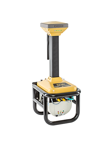
Topcon RD-M1 Scanner
Data collection in the fast lane
3D mass data collection for resurfacing.
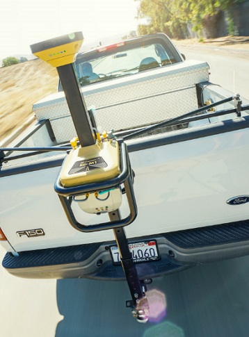
Real surface data, at speed
The RD-M1 scanner collects a constant stream of data as you drive, delivering precise surface conditions. You can quickly scan miles of road in short time, without the need for costly lane closures or re-work.
With this revolutionary solution, normal traffic conditions continue uninterrupted - dramatically saving time, eliminating the need to close lanes, and increasing the safety of your crew.
The sophisticated design works seamlessly with an integrated HiPer SR GNSS receiver as well as an Inertial Measurement Unit (IMU) to accurately capture point data while traveling at speed. Cruising at normal highways speeds, your data is automatically timestamped and instantly stored for the next step of easy management and point cloud generation.
Features:
- Downward facing LIDAR scanner for optimal road surface definition.
- Scan at speed without lane closures.
- Collect millions of points safely from the cab of the truck.
- Scan rates up to 100 times per second.
- Easy installation and removal for daily use.
- Graphical software for intuitive processing.
Topcon RD-M1 Scanner (Electrical)
- Supply Voltage: 9 to 32 VDC
- Supply Current: 3A operating current 7.5A surge current
Topcon RD-M1 Scanner (Physical)
- Housing: Powder-coated, cast aluminum
- Weight: 12.5 kg
Topcon RD-M1 Scanner (Environmental)
- Dust/Water Rating: IP66
Topcon RD-M1 Scanner (Performance)
- Scan Ratio (spacing at 40 mph every 0.6 feet): 100 scans per second, 28500 points per second, 255 intensity levels single pass scan
- Kinematic Survey Elevation Accuracy 1: < 10 mm, 1 Sigma, on curvy road section
- Kinematic Survey Elevation Accuracy 2: < 5 mm, 2 Sigma on straight road section
Product Downloads Section
Topcon RD-M1
See just how the Topcon RD-M1 works.
Topcon RD-M1 Scanner
Please contact us for more details on product rental.
Free Call: 0800-867-266
Phone: +64-9-476-5151
Email: info@synergypositioning.co.nz