
Products
- Machine Control
- GNSS Equipment
- Total Stations
- Lasers and Levels
- Aerial Mapping Systems
- Measuring Instruments
- Software
- Field Controllers
- Topcon Laser Scanning
- FARO Laser Scanning
- Mobile Mapping
- Hydrographic Survey Equipment
- Survey Accessories
- Lighting Systems
Your enquiry
Your rental enquiry
- Home
- Products
- Lasers and Levels
- Levels
- Topcon DL-500 Series
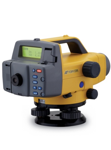
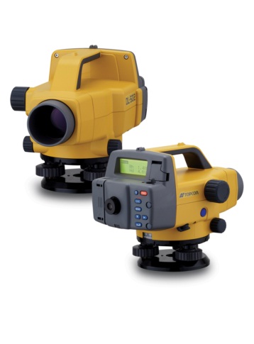
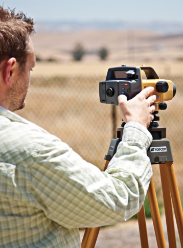
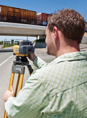
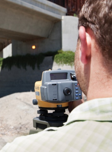
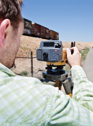
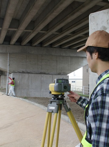
Topcon DL-500 Series
World's First "Wave-and-Read" Technology
Topcon DL-500 series digital levels maximize work efficiency and minimize human error, providing consistent measurement precision and speed, regardless of operator skill.
Incorporating cutting-edge Random-Bidirectional (RAB) coding technology, an optimized digital processing algorithm, the DL-500 provides exceptional measurement accuracy,
stability and speed, under a variety of environmental conditions. Even when the staff surface is partially shaded, or in dim lighting conditions as low as 20 lux, a single button triggers measurement and the DL-500 instantly provides reliable results.
The world's first "Wave-and-Read" technology provides an additional survey style option that allows a rod operator to wave the staff forward and back, instead of keeping the staff plumb. This simpler method is faster, easier, minimizes the fatigue and is just as accurate.
Pre-installed measurement programs assist various leveling tasks and accompanied calculations. Internal memory stores field data, and can be directly transferred to your computer via serial cable, eliminating human error.
Elevation
Calculates elevation of foresight (FS) with reference to backsight (BS) elevation. Elevation of the turning point (TP) is used for a new backsight, allowing for consecutive leveling.
Cut and Fill
Cut and fill stakeout routines facilitate slope work. Measurement can be taken with 0.1mm or 1mm (0.001ft. or 0.01ft.) resolutions.
Height Difference
Automatically displays the height difference between backsight (BS) and foresight (FS) in 0.1mm or 1mm (0.001ft. or 0.01ft.) unit.
Ceiling Height
Two measurements provide a ceiling height; one with a staff placed on the ground, the other with an inverted staff put onto the ceiling. Ceiling elevation can also be calculated with reference to the benchmark elevation.
Telescope Specifications for DL-502
- Magnification: 32X
- Objective Aperture: 45mm (1.78in.)
- Resolving Power: 3”
- Field of view: 1°20”
- Minimum Focus: 5.0ft. (1.5m)
- Image: Erect
- Stadia Ratio: 100
Telescope Specifications for DL-503
- Magnification: 28X
- Objective Aperture: 36mm (1.42in.)
- Resolving Power: 3.5”
- Field of view: 1°20”
- Minimum Focus: 5.0ft. (1.5m)
- Image: Erect
- Stadia Ratio: 100
Compensator Specifications for DL-502
- Type: With magnetic damping system
- Working range: ±15’
Compensator Specifications for DL-503
- Type: With magnetic damping system
- Working range: ±15’
Height Measurement Specifications for DL-502
- Accuracy: standard deviation for 1km
- Electronic Reading (Invar): 0.6mm
- Elect. Reading (Fiberglass): 1.0mm
- Optional reading: 1.0mm
- Measuring range: 5.3 to 328ft.
- Measuring time (Fine): 3 sec.
- Measuring time (Tracking): 1 sec.
- Least count: 0.0001/0.001m
- Minimum brightness cond.: 20lx. at the staff surface
Height Measurement Specifications for DL-503
- Accuracy: standard deviation for 1km
- Electronic Reading (Invar): 0.8mm
- Elect. Reading (Fiberglass): 1.5mm
- Optional reading: 2.0mm
- Measuring range: 5.3 to 328ft.
- Measuring time (Fine): 3 sec.
- Measuring time (Tracking): 1 sec.
- Least count: 0.0001/0.001m
- Minimum brightness cond.: 20lx. at the staff surface
Distance Measurement (D) Specifications for DL-502
- Accuracy (D 10m): ±0.4in. (±10mm)
- Accuracy (10m < D 50m): ±0.1%×D
- Accuracy (50m < D): ±0.2%×D
- Least count: 0.01/0.1m, 0.1/1ft., 1in.
Distance Measurement (D) Specifications for DL-503
- Accuracy (D 10m): ±0.4in. (±10mm)
- Accuracy (10m < D 50m): ±0.1%×D
- Accuracy (50m < D): ±0.2%×D
- Least count: 0.01/0.1m, 0.1/1ft., 1in.
User Interface Specifications for DL-502
- Display: 128×32 dot matrix LCD
- Keyboard: 8 keys
- Circular level sensitivity: 10’/2mm
User Interface Specifications for DL-503
- Display: 128×32 dot matrix LCD
- Keyboard: 8 keys
- Circular level sensitivity: 10’/2mm
Measurement Program Specifications for DL-502
- Details: Single/Continuous/Average/Elevation
Measurement Program Specifications for DL-503
- Details: Single/Continuous/Average/Elevation
Data Storage Specifications for DL-502
- Internal memory: 2,000 points
- Job: Max. 20 jobs
- Data output format: CSV
- Interface: RS-232C
Data Storage Specifications for DL-503
- Internal memory: 2,000 points
- Job: Max. 20 jobs
- Data output format: CSV
- Interface: RS-232C
Environmental Specifications for DL-502
- Water resistance: IPX4 (IEC 60529:2001)
- Operating temperature: -20°C to 50°C
- Storage temperature: -40°C to 70°C
Environmental Specifications for DL-503
- Water resistance: IPX4 (IEC 60529:2001)
- Operating temperature: -20°C to 50°C
- Storage temperature: -40°C to 70°C
Other Specifications for DL-502
- Power supply: BDC46B (Li-ion battery, 7.2V)
- Operating time: Approx. 16 hours
- Weight (including battery): 5.3lb. (2.4kg)
- Size (D x W x H): 10.1×6.2×7.2in.
Other Specifications for DL-503
- Power supply: BDC46B (Li-ion battery, 7.2V)
- Operating time: Approx. 16 hours
- Weight (including battery): 5.3lb. (2.4kg)
- Size (D x W x H): 10.1×6.2×7.2in.
Product Downloads Section
Topcon DL-500 Series
Topcon DL-500 series digital levels maximize work efficiency and minimize human error, providing consistent measurement precision and speed, regardless of operator skill.
Incorporating cutting-edge Random-Bidirectional (RAB) coding technology, an optimized digital processing algorithm, the DL-500 provides exceptional measurement accuracy, stability and speed, under a variety of environmental conditions. Even when the staff surface is partially shaded, or in dim lighting conditions as low as 20 lux, a single button triggers measurement and the DL-500 instantly provides reliable results.
The world's first "Wave-and-Read" technology provides an additional survey style option that allows a rod operator to wave the staff forward and back, instead of keeping the staff plumb. This simpler method is faster, easier, minimizes the fatigue and is just as accurate.
Pre-installed measurement programs assist various leveling tasks and accompanied calculations. Internal memory stores field data, and can be directly transferred to your computer via serial cable, eliminating human error.
- Day $80 NZD
- Week $320 NZD
- Month $880 NZD