
Products
- Machine Control
- GNSS Equipment
- Total Stations
- Lasers and Levels
- Aerial Mapping Systems
- Measuring Instruments
- Software
- Field Controllers
- Topcon Laser Scanning
- FARO Laser Scanning
- Mobile Mapping
- Hydrographic Survey Equipment
- Survey Accessories
- Lighting Systems
Your enquiry
Your rental enquiry
- Home
- Products
- Hydrographic Survey Equipment
- Unmanned Survey Vessels
- CEE HydroSystems CEE-USV
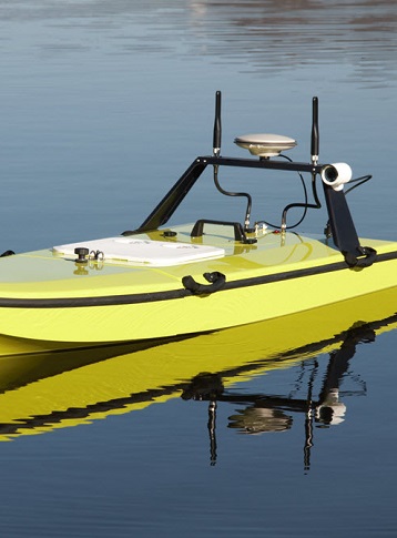
CEE HydroSystems CEE-USV
CEE-USV™ is a state of the art, high-performance survey boat incorporating a single beam echo sounder, GNSS positioning, live video, and on-board data management.
A high bandwidth radio link to the dedicated CEE-LINK™ shore station allows the operator to see precise bathymetric survey results in real time.
Since 2011, CEE HydroSystems has been working with USVs and recognized some of the challenges users face. Multiple on-board components, in come cases a dozen interconnecting cables, and numerous critical data communication settings present a significant risk of downtime through equipment setup issues. The unique CEE echo sounder technology used on the CEE-USV™ reduces the potential for field problems: all components are tightly integrated and installed in a single modular enclosure, simply turn on the power and start surveying – even when using a local RTK base station. The removable echo sounder and positioning system is fully interchangeable for manned boat surveys.
With a network (Ethernet) data link accessible through a shore laptop internal WiFi or the dedicated long range CEE-LINK™ shore radio module, data telemetry requires no user management. As soon as the USV data module is powered-up, the survey data are ready on the shore for acquisition. For security and flexibility, all survey data – position, bathymetry, and quality control information – are recorded on-board for complete redundancy, ready to be directly imported into survey software as needed.
Using the exceptional HR Wallingford ARC-Boat vehicle as the foundation of this new hydrographic drone system, the integrated CEE-USV™ is simultaneously the most advanced and easiest-to-use remotely-operated single beam survey boat on the market.
The Latest Single Beam Echo Sounder System Designed for USV Surveys
The CEE-USV has an echo sounder and positioning system specially designed for remote deployment; the new dedicated CEESCOPE-LITE manages all aspects of the survey from GNSS positioning, echo sounding data collection to real time telemetry. With a single enclosure and the absolute minimum number of connecting cables, the CEESCOPE-LITE may be removed and reinstalled after use on a manned boat in a matter of seconds.
Durable Fiberglass Hull and High Quality Fixtures and Interconnects
The CEE-USV meets an exacting standard of construction for all components from the hull to the antenna connectors.
Unique Removable Bow Flotation Module
The entire bow portion may be easily removed for transportation. The CEE-USV™ will fit into small vehicles and even helicopters, courtesy of the drastic reduction in length with the bow detached. This wonderful design feature offers users the benefit of a long hull (high performance) without the drawbacks in portability. As the bow is completely sealed, it also provides emergency flotation that ensures the boat cannot sink even if the entire rear segment is filled with water.
Fieldwork Friendly Intelligent Design
The CEE-USV is designed with the minimum number of separate components, cables, and interconnects. Our goal is to make the survey process as simple as possible from setup to data editing.
Precision Echo Sounder with Advanced Quality Control for Trustworthy Results
The CEESCOPE-LITE™ survey-grade echo sounder used in the CEE-USV™ is a highly specified hydrographic echo sounder. With a dual channel 33/200 kHz option and special programming to operate in very shallow water, CEE-USV™ bathymetry is at the highest precision attainable. Importantly, echogram quality control – full water column imaging – may be viewed in real time and provides crucial sounding quality control during data processing. With a 20 Hz ping rate, data quality and detail is remarkable.
CEE-LINK™ Convenience
CEE-USV™ uses the CEE-LINK™ shore module offering a simple solution for data transmission. Simply turn on the CEE-LINK™ and survey data are instantly available on the shore, ready to acquire with HYPACK®, Hydromagic, or any other hydrographic package. With an internal 9hr+ rechargeable battery, the CEE-LINK™ unit is self-contained, waterproof, and hassle-free, with just one setting to worry about – “on” or “off”.
Live Video Stream
With an external Ethernet input on the USV, high definition video and other ancillary data may be transmitted to the shore through the survey data link.
Long Range Operation
Antennae are raised above the water on the wing of the CEE-USV™ to greatly improve data range. Several antennae options are available to maximize operational range, up to and beyond 1km (3,300ft) distance.
Sealed Battery and Instrument Compartment
The CEE-USV™ is highly seaworthy with power packs and the CEESCOPE-LITE instrument held under a sealed watertight hatch. Batteries may be swapped in seconds without having to disconnect any of the CEESCOPE-LITE cables or even power down any of the data systems. No long interruptions.
High Quality Electrical Systems
All of the electrical systems on the CEE-USV™ are professionally installed with high capacity, high current wiring used throughout. No hobby grade or low quality switchgear or connectors are used, making the CEE-USV™ a confidence-inspiring and low risk investment.
Rugged and Durable Hull
Manufactured to exceptional quality standards, CEE-USV™ is survey-grade durable and reliable. The fiberglass hull is exceptionally strong, and stainless steel skids screwed to the hull make easy deployment and recovery with no parts to snag or snap.
Thoughtful Propulsion Setup
Over sized motors drive heavy duty prop shafts with a belt link, providing significant protection against damage should debris become caught in the props.
Rear Antenna Wing for Long Range Telemetry
The optional long range performance antenna platform raises the data and navigation (RC) antennae up off the deck level, of vital significance for avoiding destructive interference of USV to shore radio signals over the water surface.
Propulsion Battery Condition Monitoring
The shore control transmitter continuously receives a feedback signal from the CEE-USV™ showing the battery health so there is no need to worry about running out of power during the survey.
Through-Hull Instrument Mount
The transducer is mounted in the open hole through the boat, with no need for a moon pool or concerns about sealing a hole into the inside compartment. Even floating inverted, water cannot enter the CEE-USV hull.
Vehicle (Boat) Specifications
- Length: 1.2m (39″) rear section
- Length: 1.95m (77″)
- Draft: 0.18m (7″) to skids
- Beam: 0.72m (28″)
- Dry weight: 26Kg
- Detachable bow: 4Kg
- Batteries: 10kg
- Instrumentation: 8Kg
- Total weight: 48Kg
Product Downloads Section
CEE HydroSystems Remote Controlled Survey Boat USV Single Beam Echo Sounder & GPS
The next generation CEE-USV™ takes remotely-operated hydrographic surveying to the next level. With an easy-to-use fully integrated echo sounder and positioning system, simply turn on and start surveying. Powered by the advanced CEESCOPE echo sounder technology.
Installing the CEESCOPE LITE in the CEE-USV
CEE HydroSystems CEE-USV™ is exceptionally easy to set up and use. The "all in one" CEESCOPE LITE™ echo sounder and GNSS also manages data acquisition and telemetry to minimize the potential for field headaches. Simply turn on and start surveying!