
Products
- Machine Control
- GNSS Equipment
- Total Stations
- Lasers and Levels
- Aerial Mapping Systems
- Measuring Instruments
- Software
- Field Controllers
- Topcon Laser Scanning
- FARO Laser Scanning
- Mobile Mapping
- Hydrographic Survey Equipment
- Survey Accessories
- Lighting Systems
Your enquiry
Your rental enquiry
- Home
- Products
- Hydrographic Survey Equipment
- Single Beam Echo Sounders
- CEE HydroSystems CEEPULSE
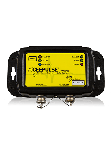
CEE HydroSystems CEEPULSE
CEEPULSE™ is an entry-level echo sounder with a difference.
Using survey-quality components throughout, and programmed with the latest CEE HydroSystems advanced bottom tracking algorithm, its consistent and accurate results inspire confidence.
Incorporating many of the features available on larger echo sounders, the CEEPULSE™ is CEE HydroSystems’ entry-level black box 200 kHz echo sounder designed for shallow water surveying. With soundings collected at up to 10 Hz using a standard or narrow beam survey grade transducer, bathymetry results are developed with a high degree of confidence.
Leading Performance: Exceptional Shallow Water Results
The CEEPULSE™ can output soundings at up to 10 Hz, giving dense bottom coverage for the most trustworthy survey results available from a “black box” echo sounder. With some design elements shared with the advanced CEESCOPE™ echo sounder, the CEEPULSE™ robust bottom-tracking algorithm offers reliable and repeatable results where other similar echo sounders cannot. Compared to basic units operating at 1-2 Hz, the CEEPULSE™ requires far less compromise in data quality to obtain a simple bathymetry survey solution.
Simplicity In Design: Modern User Interface
CEE HydroSystems’ CEE CONNECT software offers a modern and intuitive way to communicate and configure the CEEPULSE™ echo sounder, making it simple to start collecting data. Simply establish a Bluetooth connection. Data are transmitted to a survey computer for acquisition using hydrographic software such as HYPACK®, QPS QINSy, Trimble HYDROPro, or Eye4Software Hydromagic. Data may also be directly transferred using the Bluetooth port to a hand held data collector such as the Trimble TSC2 or TSC3 for incorporation into a point measurements data file.
True Survey Grade: Professional Components
Using the same professional quality hydrographic survey transducers as used with full-size echo sounder systems, the CEEPULSE™ offers a true 0.3 – 100m (1 – 328ft) depth capability and 1cm resolution. With exceptional shallow water performance, the CEEPULSE™ is ideal for small boat inland water surveys.
Physical
- Dimensions: 18 x 9 x 4 cm
- Display: Status LEDs
- Weight: 500 g
- Colour: Black
- Connectors: LEMO 1K
Environmental
- Operating temperature: 0°C – 50°C
- Humidity: 95% non condensing
- Ingress protection rating: IP68
Power
- Power consumption: 1.8 watts
- Power supply: Nominal 5.0 VDC @ 100 mA (5-24 VDC range)
Data Output
- Formats: NMEA DBT, NMEA DBS, DESO 25, ODOM, CEESTAR, CEEPULSE
- Baud rate: 9600 – 115200 (RS232, RS422)
Connectivity
- RS232: Serial data cable
- RS422: Serial data cable (optional)
- Bluetooth: Baud rate 9600 – 57600, 10 m range
Echosounder
- Mode: Auto, Shallow auto and Manual
- Frequency: High band: 190 kHz – 210 kHz
- Output Power: High: 200 kHz – 172 W RMS max
- Resolution: 1 cm
- Transducer Draft Setting: 0 – 10 m (1 cm increments)
- Index Offset: 0 – 10 m
- Blanking: 27 – 300 cm
- Ping rate: 6 Hz (10 Hz optional)
- Pulse length: 200 kHz 1-30 cycles
- TVG: None, LOG 10, LOG 20
- Manual gain: 30 – 100%
- Detection threshold: 10 – 50%
Product Downloads Section
CEE HydroSystems Single Beam CEEPULSE Echo Sounder in Shallow Water Survey
The compact CEEPULSE™ echo sounder is ideal for shallow water surveys using USVs, remotely-operated survey boats, Jon boats or small manned boats. With a rugged construction and high quality bottom tracking, good sounding data may be acquired in the most shallow environments.