Synergy Positioning Systems
  • Home
  • Products
    • Machine Control
      • Excavator
      • Dozer
      • Grader
      • Paving and Milling
      • Special Applications
      • Accessories
    • GNSS Equipment
      • GNSS Receivers
      • GNSS Antennas
      • Radio Transmitters
    • Total Stations
      • Conventional
      • Robotic
      • Monitoring
    • Lasers and Levels
      • Rotating Lasers
      • Pipe Lasers
      • Line/Cross Lasers
      • Levels
      • Accessories
    • Aerial Mapping Systems
    • Measuring Instruments
      • Structural Crack Monitoring
      • Geotechnical Testers
      • Measuring Wheels
      • Electronic Distance Meters
      • Magnetic Locators
      • Moisture meters
    • Software
      • Field
      • Design & Planning
      • Mapping
      • BIM Software
      • Telematics
    • Field Controllers
    • Topcon Laser Scanning
    • FARO Laser Scanning
      • FARO Scanners
      • Faro Software
    • Mobile Mapping
    • Hydrographic Survey Equipment
      • Single Beam Echo Sounders
      • Unmanned Survey Vessels
      • Jet Ski Survey Watercraft
      • Hydrographic Survey Software
      • PPS Synchronization
      • Tide Gauge
    • Survey Accessories
      • Tripods
      • Prisms and Holders
      • Tribrachs and Adapters
      • Levelling Staves
      • Setout Equipment
    • Lighting Systems
      • Halogen (Filament)
      • LED
      • Metal Halide Lamp
      • Quadro
      • Twinlight
      • Xenon
      • Accessories
  • Skynet RTK
  • News
  • About Us
    • Employment
    • Key Contacts
    • Vision
    • History
    • Case Studies
  • Contact Us
  • Home
  • Products

    Featured Products

    • Topcon X53i Total Station Control
      Topcon
      View Product
    • Topcon LN-100 Robotic
      Topcon
      View Product
    • Topcon SmoothRide Resurfacing
      Topcon
      View Product

    Browse, enquire & hire from our product range below

    • Machine Control
      • Excavator
      • Dozer
      • Grader
      • Paving and Milling
      • Special Applications
      • Accessories
    • GNSS Equipment
      • GNSS Receivers
      • GNSS Antennas
      • Radio Transmitters
    • Total Stations
      • Conventional
      • Robotic
      • Monitoring
    • Lasers and Levels
      • Rotating Lasers
      • Pipe Lasers
      • Line/Cross Lasers
      • Levels
      • Accessories
    • Aerial Mapping Systems
    • Measuring Instruments
      • Structural Crack Monitoring
      • Geotechnical Testers
      • Measuring Wheels
      • Electronic Distance Meters
      • Magnetic Locators
      • Moisture meters
    • Software
      • Field
      • Design & Planning
      • Mapping
      • BIM Software
      • Telematics
    • Field Controllers
    • Topcon Laser Scanning
    • FARO Laser Scanning
      • FARO Scanners
      • Faro Software
    • Mobile Mapping
    • Hydrographic Survey Equipment
      • Single Beam Echo Sounders
      • Unmanned Survey Vessels
      • Jet Ski Survey Watercraft
      • Hydrographic Survey Software
      • PPS Synchronization
      • Tide Gauge
    • Survey Accessories
      • Tripods
      • Prisms and Holders
      • Tribrachs and Adapters
      • Levelling Staves
      • Setout Equipment
    • Lighting Systems
      • Halogen (Filament)
      • LED
      • Metal Halide Lamp
      • Quadro
      • Twinlight
      • Xenon
      • Accessories
  • Skynet RTK
  • News
  • About Us
    • Employment
    • Key Contacts
    • Vision
    • History
    • Case Studies
  • Contact Us
  • 0800 867 266
  • Email Us

Products

  • Machine Control
  • GNSS Equipment
    • GNSS Receivers
    • GNSS Antennas
    • Radio Transmitters
  • Total Stations
  • Lasers and Levels
  • Aerial Mapping Systems
  • Measuring Instruments
  • Software
  • Field Controllers
  • Topcon Laser Scanning
  • FARO Laser Scanning
  • Mobile Mapping
  • Hydrographic Survey Equipment
  • Survey Accessories
  • Lighting Systems

Your enquiry

Thank you. We will get back to you as soon as possible.

  • Hide Form

Your rental enquiry

Thank you. We will get back to you as soon as possible.

  • Hide Form
  • Home
  • Products
  • GNSS Equipment
  • Topcon MC-i4
* Please note all prices exclude GST

Topcon MC-i4

Topcon
Enquire about this product Rent this product

Communication of the machine is handled by the innovative MC-i4 GNSS receiver.

The MC-i4 receiver features internal SL-R4 board which contains an integrated digital UHF radio, LongLinkTM Bluetooth, and a GSM/CDMA modem for Sitelink3D ready on almost all network connections.

The rugged design allows for ultra-reliability in even the harshest site conditions. The MC-i4 was subjected to IP67 testing specifications which require the hardware to have extreme protection against moisture and dust as well as stringent drop and vibration requirements.

Features:

  • LongLink access for LPS excavator, dozer and grader control.
  • Enhanced Sitelink3D Connectivity.
  • Digital UHF Connectivity (Standard RTK Corrections).
  • GSM or CDMA for maximum cellular connectivity (RTK Network Corrections).

Supported Systems:

  • i-33 Dozer
  • X-33 Excavator
  • i-53 Dozer
  • X-53i LPS Excavator
  • X-63i Excavator
  • Topcon MC-i4
  • Topcon MC-i4
Enquire about this product Rent this product
  • Technical Specifications
  • Downloads
  • Rental

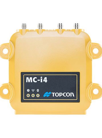
Topcon MC-i4 Receiver (GNSS)

  • Number of Channels: 144
  • Signals: GPS, GLONASS, SBAS
  • Position Accuracy 1: RTK H: 10 mm + 1.0 ppm, V: 15 mm + 1.0 ppm
  • Position Accuracy 2: DGPS H: 0.4 m, V: 0.6 m
  • Position Accuracy 3: Fast Static (L1+L2) H: 3 mm + 0.5 ppm, V: 5 mm + 0.5 ppm

Topcon MC-i4 Receiver (Electrical)

  • Supply Voltage: 9-32VDC
  • Supply Current: 600mA @ 12VDC typical 5A maximum
  • Emissions 1: Applicable Standards
  • Emissions 2: 1. Emissions : EN 55022:2007 (Class A) and EN 61000-6-4:2007
  • Emissions 3: Conducted Disturbance - 0.15 - 30 MHz
  • Emissions 4: Radiated Disturbance - 30 - 6,000 MHz
  • Emissions 5: The emissions tests also satisfied the requirements of the
  • Emissions 6: Australian EMC Framework AS/NZS 61000.6.4:2007,
  • Emissions 7: AS/NZS CISPR 22:2009 (Class A)
  • Emissions 8: 2. Immunity : EN 55024:2010 (Class A) and EN 61000-6-2:2006
  • Emissions 9: EN 61000-4-2 - Electrostatic discharge (ESD);
  • Emissions 10: EN 61000-4-3 - RF radiated susceptibility
  • Emissions 11: EN 61000-4-4 - Fast transients (EFT), burst;
  • Emissions 12: EN 61000-4-5 - Surges EN 61000-4-6 - RF
  • Emissions 13: conducted susceptibility; EN 61000-4-8 - Magnetic field immunity
  • Emissions 14: 3. ACMA Radio Communications (LIPD) Class Licence 2000
  • Emissions 15: AS/NZS 4268:2008 - Radio equipment and
  • Emissions 16: systems – Short range devices
  • Output Power: 4A max. (sensors/display)
  • Ports 1: 1 ea. port RS232 Port
  • Ports 2: 1 ea. port RS232/RS485
  • Ports 3: 1 ea. 10/100 Ethernet port
  • Ports 4: 1 ea. CAN J1939 port 50Kbps to Mbps
  • Ports 5: 1 ea. CAN J1939/CANOPEN port 50Kbps to Mbps

Topcon MC-i4 Receiver (Environmental)

  • Operating Temperature: -30°C to +70°C
  • Ingress Protection: IP-67
  • Shock test: 25G 11ms 1/2 sine wave both directions in each axis
  • Salt Spray Test: JDQ 53.3 section 4.1 (based on more generic ASTM B117-03 one)
  • Vibration Test: Random Endurance, 10-2000 Hz, 7.7 GRMS, 8 Hours each axis

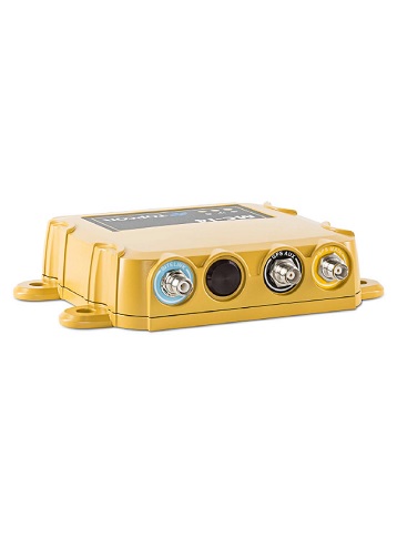
Topcon MC-i4 Receiver (Physical)

  • Housing: wder-coated, cast aluminum
  • Connectors 1: 1 ea. Deutsch DTM06 12 pin (A-coded, Gray) for power, ground, serial
  • Connectors 2: 1 ea. Deutsch DTM06 12 pin (B-coded, Black) for Ethernet and CAN
  • Connectors 3: 1 ea. RP-TNC for cellular radio
  • Connectors 4: 1 ea. RP TNC for LPS, or WiFi, or UHF radio (optional)
  • Connectors 5: 2 ea. TNC for GNSS (optional)
  • LEDs 1: 1 ea. Power 1 ea. Radio Status
  • LEDs 2: 1 ea. BlueTooth® Status
  • Weight: 2.2 lbs (1 Kg.)

Product Downloads Section

  • Topcon Synergy MC-i4 Installation Manual 3 MB pdf

Topcon MC-i4 Receiver

Please contact us for more details on product rental.

Free Call: 0800-867-266
Phone: +64-9-476-5151
Email: info@synergypositioning.co.nz

Synergy Positioning Systems A Synergy Group Company

Follow us on Twitter

Follow @SynergyPosition

Join mailing list for news & Updates

  • Home
  • Products
    • Machine Control
    • GNSS Equipment
    • Total Stations
    • Lasers and Levels
    • Aerial Mapping Systems
    • Measuring Instruments
    • Software
    • Field Controllers
    • Topcon Laser Scanning
    • FARO Laser Scanning
    • Mobile Mapping
    • Hydrographic Survey Equipment
    • Survey Accessories
    • Lighting Systems
  • Skynet RTK
  • News
  • About Us
    • Employment
    • Key Contacts
    • Vision
    • History
    • Case Studies
  • Contact Us
© 2025 Synergy Positioning Systems Ltd. All rights reserved. Website Design by 96black