
Products
- Machine Control
- GNSS Equipment
- Total Stations
- Lasers and Levels
- Aerial Mapping Systems
- Measuring Instruments
- Software
- Field Controllers
- Topcon Laser Scanning
- FARO Laser Scanning
- Mobile Mapping
- Hydrographic Survey Equipment
- Survey Accessories
- Lighting Systems
Your enquiry
Your rental enquiry
- Home
- Products
- FARO Laser Scanning
- Faro Software
- FARO SCENE 2018
FARO SCENE 2018

SCENE 2018 includes High-Detail Support Scanning which registers HD scans with a low-res main scan to decrease scan time and make registration easier for FocusS 150/350 users.
Features:
- SCENE 2018 includes new features designed to reduce scan time, increase performance, and provide high-quality visuals for scan projects.
- Make registration easier for FocusS 150/350 users.
- High-detail support scanning allows users to quickly register scan groups.
- Laser-illuminated HDR creates a composite image from camera and scan data.
- Users can also export full-color panoramic images along with a host of performance enhancements.
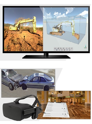
SCENE software is specifically designed for all Focus, Freestyle and third-party laser scanners. Process and manage scan data efficiently and easily by using real time, on-site registration, automatic object recognition, scan registration, and positioning. Generate high-quality data in full color quickly and conveniently by incorporating images from automated targetless and target-based scan positioning.
Users can begin the evaluation and processing immediately by performing simple measurements, creating stunning 3D visualizations or exporting to various point cloud and CAD formats once SCENE has prepared the scan data. In addition SCENE features an impressive Virtual Reality View, allowing users to experience and evaluate captured data in the VR environment.
Share and collaborate worldwide anytime, anywhere with SCENE WebShare Cloud – a hosted web-based service from FARO for easy and secure sharing of scan project data.
Rescanning of Distant Targets
SCENE 2018 supports the new scanner functionality equipped with rescanning of distant areas that need to be scanned with higher resolution, either to perform accurate target recognition or to capture smaller areas with greater detail accuracy.
Laser-HDRTM* Image Creation
SCENE 2018 supports the new scanner functionality equipped with rescanning of distant areas that need to be scanned with higher resolution, either to perform accurate target recognition or to capture smaller areas with greater detail accuracy.
Export of high resolution panoramic images
SCENE now exports high resolution panoramic images from even low resolution scans. In addition to time savings, users no longer need additional equipment, such as a separate digital camera, on site.
Impressive Virtual Reality Viewer
SCENE’s Virtual Reality functionality permits viewing project point clouds in full detail. Users can select between Oculus Rift and HTC Vive glasses to experience and explore on-site situations back in the office in immerisive detail.
Flexible Data Registration
Shared markers (coded targets) support combined harmonized FARO Focus and Freestyle data processing and registration.
Real Time On-Site Registration
SCENE features a real time, on-site registration which enables 3D scan data to be wirelessly transmitted, processed, aligned and registered directly to an onsite mobile device or PC in real time*.
Scanner Control Task
In SCENE 7.1 the user can control the FARO Focus S or M Laser Scanner remotely by directly connecting to the device wirelessly via the SCENE user interface.
Overview Map
Create an overview map of the entire scan project. This map can be created from SCENE projects with the touch of a button and will be automatically created during the on-site registration.
On-site Compensation
Verify and adjust the scanner’s compensation on-site or in the office. SCENE and SCENE LT support this functionality for all new FocusS Laser Scanners.*
3D Mesh Engine
The SCENE 3D mesh engine creates watertight meshes of scanned object surfaces in rich detail from 3D selections or clippings. A new smoothing option reduces measurement noise and create meshes with a smooth texture. Supported mesh formats are: .stl, .obj, .ply and .wrl (VRML).
Powerful solid 3D surfaces rendering
The state-of-the-art solid surfaces rendering engine is capable of displaying enormous amounts of scan points very quickly and with high quality.
HDR mapping
The fully automatic HDR mapping function permits to preserve the image details and colour appearance of the scan data registered with a Focus Laser Scanner** even in challenging lighting situations.
Create Ortho-Image
The Ortho-Image function allows users to create ortho-images in every alignment of the image plane. Users can also export the 2D images in x-ray mode via the common image file types and as 2D/ 3D .dxf files.
Intuitive user interface
Upload scans, sections, and complete project point clouds directly to WebShare Cloud with all applied filters resulting in exceptional 3D visual 3D quality data.
WebShare Cloud Integration
Upload scans, sections, and complete project point clouds directly to WebShare Cloud with all applied filters resulting in exceptional 3D visual quality data.
Plug-Ins for extended functionality
The unique plug-in interface lets permits users to extend SCENE´s functionality by installing additional apps. All apps are on the FARO 3D App Center.
System Requirements (Recommended)
- Processor: Quad-core X64, Intel Core i7/Xeon, 8 physical cores
- Graphics Card: Dedicated graphics card, OpenGL 4.1 or higher, at least 4 GB Memory
- For Stereo Rendering: NVIDIA Quadro
- For VR Rendering: NVIDIA 1080GTX or similar
- SteamVR: Must be installed
- Supported VR Headsets: Windows Mixed Reality, Oculus Rift with Touch Controllers, HTC Vive
- Main Memory: 64 GB RAM
- Hard Disk Drive: 512 GB Solid State Drive + Regular HDD
- Operating System: 64-bit Windows™ 7 SP1 or higher
- Screen resolution: 1920×1080
- Supported Hardware: FocusM 70, FocusS 70/150/250, Focus3D X 30/130/330, Focus3D X HDR 130/330 and Freestyle3D
System Requirements (Accessories)
- Accessory 1: Mouse with 2 buttons and a scroll wheel, Internet connection for licensing SCENE
Product Downloads Section
SCENE 2018 WhatsNew
SCENE 2018 offers several new features including High-Detail Support Scanning, Laser-Illuminated HDR, Full-Color Panoramas and more. This five minute video shows you everything new in SCENE 2018.
FARO SCENE 2018: High Detail Scan Support - English
SCENE 2018 includes High-Detail Support Scanning which registers HD scans with a low-res main scan to decrease scan time and make registration easier for FocusS 150/350 users.