Synergy Positioning Systems
  • Home
  • Products
    • Machine Control
      • Excavator
      • Dozer
      • Grader
      • Paving and Milling
      • Special Applications
      • Accessories
    • GNSS Equipment
      • GNSS Receivers
      • GNSS Antennas
      • Radio Transmitters
    • Total Stations
      • Conventional
      • Robotic
      • Monitoring
    • Lasers and Levels
      • Rotating Lasers
      • Pipe Lasers
      • Line/Cross Lasers
      • Levels
      • Accessories
    • Aerial Mapping Systems
    • Measuring Instruments
      • Structural Crack Monitoring
      • Geotechnical Testers
      • Measuring Wheels
      • Electronic Distance Meters
      • Magnetic Locators
      • Moisture meters
    • Software
      • Field
      • Design & Planning
      • Mapping
      • BIM Software
      • Telematics
    • Field Controllers
    • Topcon Laser Scanning
    • FARO Laser Scanning
      • FARO Scanners
      • Faro Software
    • Mobile Mapping
    • Hydrographic Survey Equipment
      • Single Beam Echo Sounders
      • Unmanned Survey Vessels
      • Jet Ski Survey Watercraft
      • Hydrographic Survey Software
      • PPS Synchronization
      • Tide Gauge
    • Survey Accessories
      • Tripods
      • Prisms and Holders
      • Tribrachs and Adapters
      • Levelling Staves
      • Setout Equipment
    • Lighting Systems
      • Halogen (Filament)
      • LED
      • Metal Halide Lamp
      • Quadro
      • Twinlight
      • Xenon
      • Accessories
  • Skynet RTK
  • News
  • About Us
    • Employment
    • Key Contacts
    • Vision
    • History
    • Case Studies
  • Contact Us
  • Home
  • Products

    Featured Products

    • Topcon LN-100 Robotic
      Topcon
      View Product
    • Topcon X53i Total Station Control
      Topcon
      View Product
    • Topcon SmoothRide Resurfacing
      Topcon
      View Product

    Browse, enquire & hire from our product range below

    • Machine Control
      • Excavator
      • Dozer
      • Grader
      • Paving and Milling
      • Special Applications
      • Accessories
    • GNSS Equipment
      • GNSS Receivers
      • GNSS Antennas
      • Radio Transmitters
    • Total Stations
      • Conventional
      • Robotic
      • Monitoring
    • Lasers and Levels
      • Rotating Lasers
      • Pipe Lasers
      • Line/Cross Lasers
      • Levels
      • Accessories
    • Aerial Mapping Systems
    • Measuring Instruments
      • Structural Crack Monitoring
      • Geotechnical Testers
      • Measuring Wheels
      • Electronic Distance Meters
      • Magnetic Locators
      • Moisture meters
    • Software
      • Field
      • Design & Planning
      • Mapping
      • BIM Software
      • Telematics
    • Field Controllers
    • Topcon Laser Scanning
    • FARO Laser Scanning
      • FARO Scanners
      • Faro Software
    • Mobile Mapping
    • Hydrographic Survey Equipment
      • Single Beam Echo Sounders
      • Unmanned Survey Vessels
      • Jet Ski Survey Watercraft
      • Hydrographic Survey Software
      • PPS Synchronization
      • Tide Gauge
    • Survey Accessories
      • Tripods
      • Prisms and Holders
      • Tribrachs and Adapters
      • Levelling Staves
      • Setout Equipment
    • Lighting Systems
      • Halogen (Filament)
      • LED
      • Metal Halide Lamp
      • Quadro
      • Twinlight
      • Xenon
      • Accessories
  • Skynet RTK
  • News
  • About Us
    • Employment
    • Key Contacts
    • Vision
    • History
    • Case Studies
  • Contact Us
  • 0800 867 266
  • Email Us

Products

  • Machine Control
  • GNSS Equipment
  • Total Stations
  • Lasers and Levels
  • Aerial Mapping Systems
  • Measuring Instruments
  • Software
  • Field Controllers
  • Topcon Laser Scanning
  • FARO Laser Scanning
    • FARO Scanners
    • Faro Software
  • Mobile Mapping
  • Hydrographic Survey Equipment
  • Survey Accessories
  • Lighting Systems

Your enquiry

Thank you. We will get back to you as soon as possible.

  • Hide Form

Your rental enquiry

Thank you. We will get back to you as soon as possible.

  • Hide Form
  • Home
  • Products
  • FARO Laser Scanning
  • Faro Software
  • FARO As-Built™ for AutoCAD® Software
* Please note all prices exclude GST

FARO As-Built™ for AutoCAD® Software

Faro
Enquire about this product

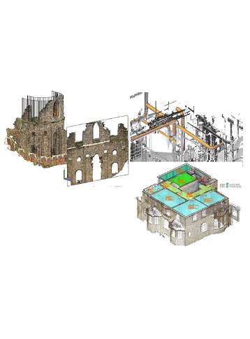
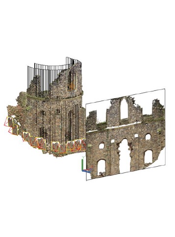
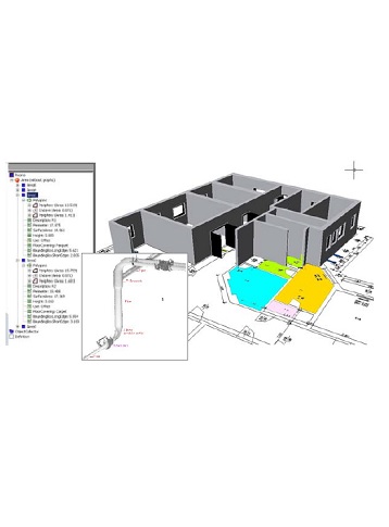
As-Built for AutoCAD Software provides powerful tools to derive plans, image plans and 3D models from point clouds for as-built data collection and planning in architecture, construction and engineering.

Plant components and piping systems can be automatically detected and recorded with all their parameters. Exact connection points can be determined without modeling. Analysis tools serve for quality control of the modelled object as well as for the determination and visualization of deformations. The integrated feature data capture is useful for facility management and real estate management, as well as for component lists from piping systems or for damage mapping on facades of historical buildings. Photogrammetry tools are a valuable addition to the inventory and documentation of historical buildings in particular in historic preservation and building research.

  • FARO As-Built™ for AutoCAD® Software
  • FARO As-Built™ for AutoCAD® Software
  • FARO As-Built™ for AutoCAD® Software
  • FARO As-Built™ for AutoCAD® Software
  • FARO As-Built™ for AutoCAD® Software
Enquire about this product
  • Technical Specifications
  • Downloads
  • Videos

Technical Requirements

  • Platform 1: AutoCAD Software 2015 and above.
  • Platform 2: Also compatible with associated products e.g. Civil 3D, Architecture®, Map 3D®.
  • Operating system: Dependent on the version of AutoCAD Software, 64-bit systems only.
  • Recommended hardware requirements 1: Graphics card as recommended by Autodesk
  • Recommended hardware requirements 2: RAM at least 8 GB, better 32GB and more
  • Recommended hardware requirements 3: Processor at least 2.5 GHz, better 3-4 GHz and 4-8 cores
  • Recommended hardware requirements 4: SSD for larger projects
  • Data requirements: Registered scans (and images).
  • Supported scan data formats 1: E57, ASCII, LAS, FARO (LSPROJ, FLS, FWS)
  • Supported scan data formats 2: Leica (PTZ, PTS, PTX)
  • Supported scan data formats 3: Zoller&Fröhlich (ZFS, ZFPRJ)
  • Supported scan data formats 4: Topcon (CL3, CLR) Leica (PTG)
  • Supported scan data formats 5: Riegl RiScanPro-Projects (RSP)

Product Downloads Section

  • FARO As-Built for AutoCAD Software Tech Sheet 1 MB pdf
  • Faro As Built for AutoCAD 2018 TS Total Station Interface User Manual 6 MB pdf
  • Faro As Built for AutoCAD 2018 Feature Data Capture and Management User Manual 4 MB pdf
  • Faro As Built for AutoCAD 2018 Main Features User Manual 7 MB pdf
  • Faro As Built for AutoCAD 2018 Photo Photogrammetry Tools User Manual 6 MB pdf

As Built for AutoCAD Software 2018 Overview

  • Evaluate data of a variety of sensors (scanners, UAVs, cameras, and total stations).
  • Offers a comprehensive range of features for Architecture, Plant/Engineering, Civil/Infrastructure, and Surveying/Facility Management.
  • Fully integrated part of the FARO system solution.
Synergy Positioning Systems A Synergy Group Company

Follow us on Twitter

Follow @SynergyPosition

Join mailing list for news & Updates

  • Home
  • Products
    • Machine Control
    • GNSS Equipment
    • Total Stations
    • Lasers and Levels
    • Aerial Mapping Systems
    • Measuring Instruments
    • Software
    • Field Controllers
    • Topcon Laser Scanning
    • FARO Laser Scanning
    • Mobile Mapping
    • Hydrographic Survey Equipment
    • Survey Accessories
    • Lighting Systems
  • Skynet RTK
  • News
  • About Us
    • Employment
    • Key Contacts
    • Vision
    • History
    • Case Studies
  • Contact Us
    • Auckland
    • Hamilton
    • Wellington
    • Christchurch
    • Support
© 2025 Synergy Positioning Systems Ltd. All rights reserved. Website Design by 96black