News
- Topcon top of the pack for Finnish National Land Survey
- GPS Week Rollover
- A double win for Synergy at the Topcon Xperience Awards 2018!
- Topcon introduces new software for UAV inspection applications
- Topcon Talks About The Future of Construction in New Zealand
- International awards recognition for Synergy Positioning Systems
Newsletters
View all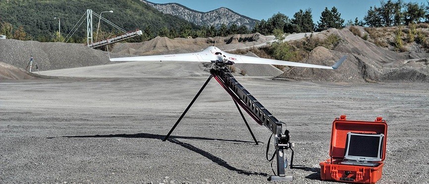
Product Spotlight: C-Astral Bramor rTK UAV
|
|
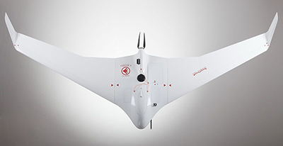
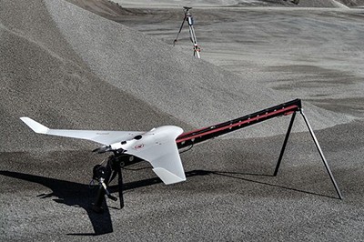
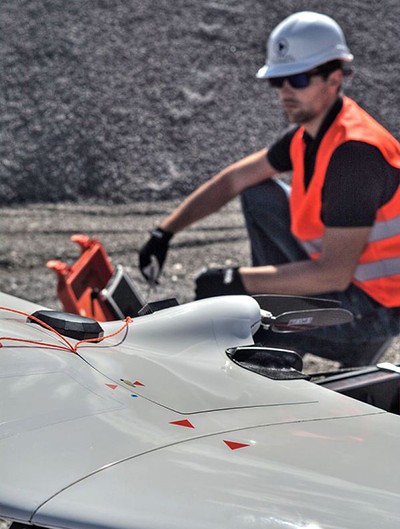
May 4, 2015 – With growth in the UAV sector at unparalleled levels it is only natural that associated technologies are likewise evolving at speed. The latest system being adopted by UAV manufacturer C-Astral Aerospace is Real Time Kinematic (RTK) GPS; an advent that is set to change the way geospatial survey data is gathered forever. RTK technology has the potential to create accurate aerial survey information of even the most remote terrain, while giving UAV consultants such as Synergy Positioning increased flexibility to turn around data for clients quickly. RTK GPS is captured inside the UAV while the craft is flying and is proving accurate enough for land forms to be successfully mapped without the need for ground control points. C-Astral Aerospace’s new Bramor rTK UAV system is comprised of both air and ground segments; a state of the art GNSS RTK on board receiver and ruggedised ground base station. Combining high precision autonomous operations with data acquisition, turbulent air penetration and stability with industry-leading endurance of up to 2.5 hours, the Bramor rTK blended wing body modular airframe features various sensor options, a portable and ergonomic ground control station and a catapult launcher. The airframe is made of advanced composite materials (Kevlar/Carbon/Vectran) that provide a high level of survivability. A high visibility colour scheme, strobe and NAV lights are optional extras. Embedded autonomous flight procedures include an array of fail-safe options for operator and stakeholder peace of mind. The whole system fits into two rugged transport cases or a single back pack, can be flight-ready in under five minutes and safely operated by a single operator/pilot in command. The platform can take off and fly its data capture mission autonomously before performing a parachute landing at a designated point. The Bramor rTK boasts an operational ceiling of 5000m AGL and is capable of operating in winds of up to 60km/h. Equipped with C-Astral high rate GPS and IMU precision data-logging electronics, processing time is shortened by the ability to acquire the same amount of data and consistent overlaps when flying against or with the wind. The Bramor rTK onboard system consists of a 24.3Megapixel colour, infrared, NDVI, hyperspectral, multispectral or gas spectrometer sensor and is directly compatible with EnsoMOSAIC, PIEneering, Pix4D, Agisoft Photoscan, Menci Software and other image processing software solutions. RTK technology does away with the need for ground reference points. This enables technical support teams from aerial mapping consultancies such as Synergy Positioning Systems to instead place a base station on a LINZ mark, such as a trig beacon, within five or 10km of the survey area, then head into the area and complete the flight mission before retrieving the base station on the return journey. Pairing this technology with the high performance durability and stability of C-Astral Aerospace UAVs ensures the Bramor rTK is the ultimate high productivity unmanned aerial platform for global surveying and remote sensing in remote areas. |