
Products
- Machine Control
- GNSS Equipment
- Total Stations
- Lasers and Levels
- Aerial Mapping Systems
- Measuring Instruments
- Software
- Field Controllers
- Topcon Laser Scanning
- FARO Laser Scanning
- Mobile Mapping
- Hydrographic Survey Equipment
- Survey Accessories
- Lighting Systems
Your enquiry
Your rental enquiry
- Home
- Products
- Total Stations
- Robotic
- Topcon IS-3 Imaging Robotic
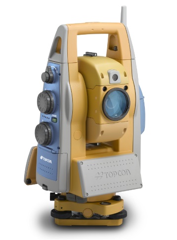
Topcon IS-3 Imaging Robotic
The World’s First Long-Range Robotic Scanning Instrument, The IS-3!
The power, accuracy, and speed of a Total Station with the auto-scanning capabilities of a Laser Scanner; Topcon’s IS-3 takes material management, as-built design, and structural/environmental monitoring out of the clouds and puts it at your fingertips…
A New Way To Scan
Topcon’s IS-3 combines the best of two worlds, advanced imaging and high-accuracy surveying, incorporating real-time field imagery with spatial data. The IS-3’s powerful functionality is controlled using Topcon’s exclusive ImageMaster™ software that produces “photography with dimension”, a revolutionary and cost effective alternative to laser scanning.
Long Range Scanning
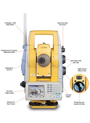
Nobody can provide the combination of laser scanning and robotic surveying like Topcon with the IS-3. The long non-prism (6,500’ (2,000m)) robotic instrument now can scan long ranges as well. Mining and monitoring applications can be accomplished with the IS-3.
Remote Networking
The IS-3 has WLAN capability and can be controlled remotely. Imagine sitting in the comfort of your office or vehicle and being able to scan, measure, control, and see what the IS-3 is seeing.
Touch Drive - Turn And Select A Point On Screen
Simply touch the screen image to drive the cross hairs where you want. For the highest degree of data accuracy, clarity of image is key. That’s why Topcon incorporates telescopic zoom with a LCD. Using the telescope, pinpoint features to be measured or monitored precisely up to 6,500’ (2,000m) away.
Does more than a robotic instrument! Does more than a laser scanner! The Topcon IS-3 combines the power of both a laser scanner and a robotic instrument into one superior long-range, imaging robotic system.
How it Works
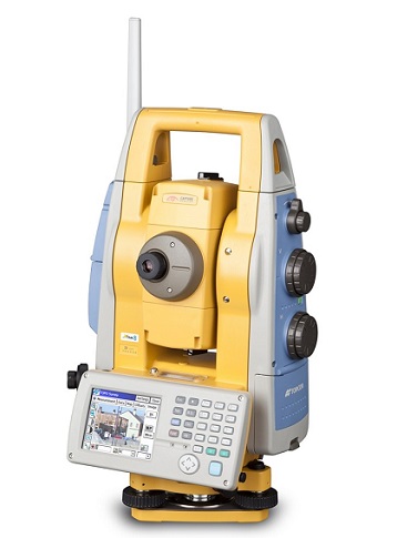
Topcon’s IS-3 features dual digital imaging cameras providing a color, real-time image on the touch LCD display.
To define a scan area, simply tap the image display, or for uniform measurement of an area, select the grid feature. The IS-3 “locks” these points to their exact position on the image, even when the instrument is rotated.
Once all points to be measured are chosen, the IS-3 performs a reflectorless measurement of each point.
Recommended Systems:
Robotic Package
- Topcon IS-3
- Robotic Kit
- On-board TopSURV
- ImageMaster IS Version
Applications: Topographic Land Surveys, Boundary Surveys, Construction Layout, Scanning from on-board TopSURV, Scanning from WiFi connected ImageMaster running on a PC.
Scanning Package
- Topcon IS-3
- ImageMaster Standard Version
- On-board TopSURV
- No Robotic Kit
Applications: Long-range Scanning: quarry, mining, construction site, landfills. Mid-range Scanning: bridge, embankments, dams, levy, monitoring. Short-range Scanning: interior of buildings, lot as-builts.
The IS-3 And Accessories Fit Into One Case
- Imaging Station
- Carrying Case
- (3) Batteries BT-65Q
- (1) Double Charger
- Tribrach
- USB Cable
- On-board TopSURV
- ImageMaster IS
- CDs Support Material
- (2) Carrying Straps
- Sun and Rain Shields
Angle Measurement
- Method: Absolute Reading
- Minimum Reading: 1”/5” (0.1/0.5mgon)
- Accuracy: 1”, 3”, 5” (0.3mgon)
- Tilt Correction: Dual Axis
- Compensating Range: ±6’ (1.8m)
Distance Measurement
- 1 prism: 9,840’ (3,000m)
- 3 prism: 13,120’ (4,000m)
- 9 prism: 16,400’ (5,000m)
- Non-Prism Mode: 4.9’ - 820’ (1.5m - 250m)
- Non-Prism Long Mode: 16.4’ - 6,500’ (5.0m - 2,000m)
Measuring Accuracy
- Prism: Fine ±(2mm+2ppmxD*) m.s.e.
- Non-Prism: Fine ±(3mm) m.s.e.
- Non-Prism Long Mode: ±(10mm+10ppmxD*) m.s.e.
Imaging
- Cameras Image Speed: (2) 1.3mp
- Image speed: 1 - 10fps
- Scanning: Max 20 pts/sec
User Interface
- OS: Microsoft Win® CE.NET 4.2
- Processor: Intel® PXA255 400Mhz
- Screen: Full Color Touch-screen
Product Downloads Section
Topcon IS Series Total Station
Topcon's IS combines the best of two worlds, advanced imaging and high-accuracy surveying, incorporating real-time field imagery with spatial data. The IS's powerful functionality is controlled using Topcon's exclusive ImageMaster software that produces "photography with dimension", a revolutionary and cost effective alternative to laser scanning. Reality captured for results unimaginable.
Topcon IS-3 Imaging Station
Please contact us for more details on product rental.
Free Call: 0800-867-266
Phone: +64-9-476-5151
Email: info@synergypositioning.co.nz