
Products
- Machine Control
- GNSS Equipment
- Total Stations
- Lasers and Levels
- Aerial Mapping Systems
- Measuring Instruments
- Software
- Field Controllers
- Topcon Laser Scanning
- FARO Laser Scanning
- Mobile Mapping
- Hydrographic Survey Equipment
- Survey Accessories
- Lighting Systems
Your enquiry
Your rental enquiry
- Home
- Products
- Software
- Telematics
- Topcon Sitelink3D Enterprise – Real-Time Site Management
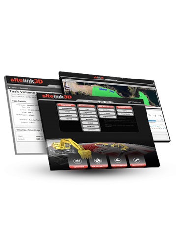
Topcon Sitelink3D Enterprise – Real-Time Site Management
Your virtual jobsite, just one click away
Radically improve visibility and management with cloud-based dashboards.
Real-time 3D planning, scheduling and reporting
Enterprise is a Sitelink3D module you can use to plan, schedule, assign tasks and get reports, all in real time. Web-based access allows you to manage your job from anywhere. Sitelink3D Enterprise is a direct extension of every equipped machine on the site, along with every survey rover, giving you the deal jobsite data, remotely.
- Build production plans based on site plans
- Assign Tasks to each machine, and track against the plan in real time
- Generate haul reports in conjunction with HT-30 haul truck system
- Send Tasks and texts directly to each control box
- See your progress with real-time as-built mapping
- Real-time 3D Vizualizer lets you see your site right now!
- Gantt charts for Tasks and dependencies
Topcon Sitelink3D Enterprise (Connectivity)
- Monitoring 1: View machine location and movement from any Internet-connected device
- Monitoring 2: Operators see other machines
- Remote Support 1: Train and assist operators from any Internet-connected device
- Remote Support 2: Reduce service calls using remote troubleshooting
- Remote Support 3: Update software and firmware remotely
- File Transfer 1: Send any file, to any or every machine
- File Transfer 2: Send files even when machines are offline
- File Transfer 3: Machines can send files to the office
- Messaging 1: Send messages to machines
- Messaging 2: Receive messages from machines
Topcon Sitelink3D Enterprise (Productivity)
- As-built Data: Reduce survey costs by collecting surface data as the machines work
- Live Color Mapping 1: Managers can view cut/fill or pass count color maps remotely via sitelink3d.net
- Live Color Mapping 2: Operators can view live color maps as they work
- Tasks 1: Schedule and assign custom tasks
- Tasks 2: Keep everyone informed
- Reporting 1: Monitor productivity in real time
- Reporting 2: Quickly generate customized productivity reports
- Reporting 3: View volume, pass count, haul, and compaction
Product Downloads Section
Topcon Sitelink3D Enterprise
Please contact us for more details on product rental.
Free Call: 0800-867-266
Phone: +64-9-476-5151
Email: info@synergypositioning.co.nz