Synergy Positioning Systems
  • Home
  • Products
    • Machine Control
      • Excavator
      • Dozer
      • Grader
      • Paving and Milling
      • Special Applications
      • Accessories
    • GNSS Equipment
      • GNSS Receivers
      • GNSS Antennas
      • Radio Transmitters
    • Total Stations
      • Conventional
      • Robotic
      • Monitoring
    • Lasers and Levels
      • Rotating Lasers
      • Pipe Lasers
      • Line/Cross Lasers
      • Levels
      • Accessories
    • Aerial Mapping Systems
    • Measuring Instruments
      • Structural Crack Monitoring
      • Geotechnical Testers
      • Measuring Wheels
      • Electronic Distance Meters
      • Magnetic Locators
      • Moisture meters
    • Software
      • Field
      • Design & Planning
      • Mapping
      • BIM Software
      • Telematics
    • Field Controllers
    • Topcon Laser Scanning
    • FARO Laser Scanning
      • FARO Scanners
      • Faro Software
    • Mobile Mapping
    • Hydrographic Survey Equipment
      • Single Beam Echo Sounders
      • Unmanned Survey Vessels
      • Jet Ski Survey Watercraft
      • Hydrographic Survey Software
      • PPS Synchronization
      • Tide Gauge
    • Survey Accessories
      • Tripods
      • Prisms and Holders
      • Tribrachs and Adapters
      • Levelling Staves
      • Setout Equipment
    • Lighting Systems
      • Halogen (Filament)
      • LED
      • Metal Halide Lamp
      • Quadro
      • Twinlight
      • Xenon
      • Accessories
  • Skynet RTK
  • News
  • About Us
    • Employment
    • Key Contacts
    • Vision
    • History
    • Case Studies
  • Contact Us
  • Home
  • Products

    Featured Products

    • Topcon X53i Total Station Control
      Topcon
      View Product
    • Topcon SmoothRide Resurfacing
      Topcon
      View Product
    • Topcon LN-100 Robotic
      Topcon
      View Product

    Browse, enquire & hire from our product range below

    • Machine Control
      • Excavator
      • Dozer
      • Grader
      • Paving and Milling
      • Special Applications
      • Accessories
    • GNSS Equipment
      • GNSS Receivers
      • GNSS Antennas
      • Radio Transmitters
    • Total Stations
      • Conventional
      • Robotic
      • Monitoring
    • Lasers and Levels
      • Rotating Lasers
      • Pipe Lasers
      • Line/Cross Lasers
      • Levels
      • Accessories
    • Aerial Mapping Systems
    • Measuring Instruments
      • Structural Crack Monitoring
      • Geotechnical Testers
      • Measuring Wheels
      • Electronic Distance Meters
      • Magnetic Locators
      • Moisture meters
    • Software
      • Field
      • Design & Planning
      • Mapping
      • BIM Software
      • Telematics
    • Field Controllers
    • Topcon Laser Scanning
    • FARO Laser Scanning
      • FARO Scanners
      • Faro Software
    • Mobile Mapping
    • Hydrographic Survey Equipment
      • Single Beam Echo Sounders
      • Unmanned Survey Vessels
      • Jet Ski Survey Watercraft
      • Hydrographic Survey Software
      • PPS Synchronization
      • Tide Gauge
    • Survey Accessories
      • Tripods
      • Prisms and Holders
      • Tribrachs and Adapters
      • Levelling Staves
      • Setout Equipment
    • Lighting Systems
      • Halogen (Filament)
      • LED
      • Metal Halide Lamp
      • Quadro
      • Twinlight
      • Xenon
      • Accessories
  • Skynet RTK
  • News
  • About Us
    • Employment
    • Key Contacts
    • Vision
    • History
    • Case Studies
  • Contact Us
  • 0800 867 266
  • Email Us

Products

  • Machine Control
  • GNSS Equipment
  • Total Stations
  • Lasers and Levels
  • Aerial Mapping Systems
  • Measuring Instruments
  • Software
    • Field
    • Design & Planning
    • Mapping
    • BIM Software
    • Telematics
  • Field Controllers
  • Topcon Laser Scanning
  • FARO Laser Scanning
  • Mobile Mapping
  • Hydrographic Survey Equipment
  • Survey Accessories
  • Lighting Systems

Your enquiry

Thank you. We will get back to you as soon as possible.

  • Hide Form

Your rental enquiry

Thank you. We will get back to you as soon as possible.

  • Hide Form
  • Home
  • Products
  • Software
  • Design & Planning
  • ClearEdge3D Verity
* Please note all prices exclude GST

ClearEdge3D Verity

ClearEdge3D
Enquire about this product

Construction Verification Software. Find mistakes before they become expensive problems.

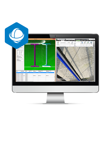
Verity from ClearEdge3D compares point clouds against design and fabrication models, allowing 100% verification of work in the time it takes to spot check 5%. Provide a complete record and validation of work installed per specification and detailed information on any deviations. Verity is fully integrated with Autodesk Navisworks and is design to offer the transparency needed to reduce costly rework from as-built variances.

  • Clear indication of construction quality with as-built to tolerances
  • Reduce risks to budgets and schedules
  • Increase project profitability by avoiding rework
  • Fully integrated with Autodesk Navisworks
  • Compare to your 4D simulation to stay on track

End-to-end Scanning Solution

After capturing a point cloud with the GLS-2000 and rapidly processing with MAGNET Collage, ClearEdge3D automated modeling and object recognition software completes the process by creating as-built documentation and construction verification. Together, Topcon and ClearEdge3D provide the ideal BIM modeling end-to-end solution.

  • ClearEdge3D Verity
Enquire about this product
  • Technical Specifications
  • Downloads
  • Videos

ClearEdge3D Verity Specs

  • Reduce: Costly Rework from As-Built Variances
  • Deliver: Accurate As-Built Models and Drawings
  • Clash Detect: Autodesk Navisworks As-Builts Using Verity
  • Communicate Findings: To All Stakeholders

Product Downloads Section

  • ClearEdge3D Verity Brochure 1 MB pdf

Introduction to Verity Construction Verification Software

The following is an introductory video for Verity construction verification software created by ClearEdge3D.   Verity compares point clouds against design & fabrication models, allowing you to verify 100% of your work in the time it currently takes you to spot check 5%. The software helps you find construction mistakes before they become expensive problems.

Synergy Positioning Systems A Synergy Group Company

Follow us on Twitter

Follow @SynergyPosition

Join mailing list for news & Updates

  • Home
  • Products
    • Machine Control
    • GNSS Equipment
    • Total Stations
    • Lasers and Levels
    • Aerial Mapping Systems
    • Measuring Instruments
    • Software
    • Field Controllers
    • Topcon Laser Scanning
    • FARO Laser Scanning
    • Mobile Mapping
    • Hydrographic Survey Equipment
    • Survey Accessories
    • Lighting Systems
  • Skynet RTK
  • News
  • About Us
    • Employment
    • Key Contacts
    • Vision
    • History
    • Case Studies
  • Contact Us
© 2025 Synergy Positioning Systems Ltd. All rights reserved. Website Design by 96black