
Products
- Machine Control
- GNSS Equipment
- Total Stations
- Lasers and Levels
- Aerial Mapping Systems
- Measuring Instruments
- Software
- Field Controllers
- Topcon Laser Scanning
- FARO Laser Scanning
- Mobile Mapping
- Hydrographic Survey Equipment
- Survey Accessories
- Lighting Systems
Your enquiry
Your rental enquiry
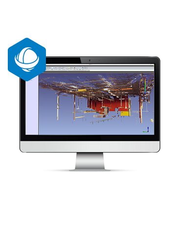
ClearEdge3D EdgeWise
3D modeling with automated feature extraction and object recognition. Reduce your modeling time by up to 75%.
EdgeWise™ software from ClearEdge3D offers a host of modeling features and tools that help users quickly take point clouds and convert them to usable as-built 3D plant and building models. As the industry's most technological advanced as-built modeling platform, EdgeWise utilizes automated feature extraction, pattern recognition technology, and object recognition algorithms to reduce your modeling time by hours, days, and even weeks.
- Increase accuracy and speed when modeling
- Model 3d as-built pipes, structural elements, ducts, walls, tees, and conduits
- MEP, structural, and Architectural modeling capabilities
- Billion-point visualization engine with photo-realistic project view
- Fully interoperable with Plant3D, CADWorx, PDMS, and Autodesk Revit
End-to-end Scanning Solution
After capturing a point cloud with the GLS-2000 and rapidly processing with MAGNET Collage, ClearEdge3D automated modeling and object recognition software completes the process by creating as-built documentation and construction verification. Together, Topcon and ClearEdge3D provide the ideal BIM modeling end-to-end solution.
ClearEdge3D EdgeWise Specifications
- Plant Modeling Capabilities: Yes
- MEP Modeling Capabilities: Yes
- Steel & Concrete Modeling Capabilities: Yes
- Architectural Modeling Capabilities: Yes
- Compatible Scanner File Formats: .fls; .ptg; .ptx; .zfs; .zfprj, .e57; .tzf; .dp
Product Downloads Section
EdgeWise Overview Video
This video shows the various features in ClearEdge3D's popular EdgeWise software. The 6 minute video looks at the pipe, structure, duct, ground, and architectural as well as the EdgeWise 5.0's intelligent export to Revit, PDMS, Plant3D, PCF, AutoCAD and more.