
Products
- Machine Control
- GNSS Equipment
- Total Stations
- Lasers and Levels
- Aerial Mapping Systems
- Measuring Instruments
- Software
- Field Controllers
- Topcon Laser Scanning
- FARO Laser Scanning
- Mobile Mapping
- Hydrographic Survey Equipment
- Survey Accessories
- Lighting Systems
Your enquiry
Your rental enquiry
- Home
- Products
- Mobile Mapping
- Topcon IP-S3 HD1
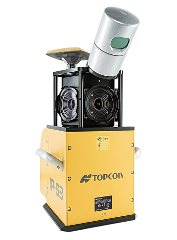
Topcon IP-S3 HD1
The Ultimate in Feature Recognition and Mapping
- Integrated, turnkey solution
- Ultra-compact design
- Multiple lasers minimize scanning shades
- Unparalleled ease-of-use
- No user calibration required
- Full integration of cloud and images
The lightweight, compact IP-S3 HD1 offers a high-density point cloud with colorful image overlays
The IP-S3 HD1 bundles the longstanding experience of Topcon in mobile mapping systems in a small package. The system overcomes the challenges of mapping 3D features at a high level of accuracy. Accurate vehicle positions are obtained using three technologies: A dual frequency GNSS receiver establishes a geospatial position; an Inertial Measurement Unit (IMU) provides vehicle attitude; and connection to the vehicle or external wheel encoder obtains odometry information. These three technologies work in tandem to sustain a highly accurate 3D position for the vehicle even in locations where satellite signals can be blocked by obstructions such as buildings, bridges, or tree lines.
The IP-S3 HD1 system includes a single sensor head of LiDAR containing lasers oriented to cover roadside features up to 100 meters away. The panoramic, high-resolution 30 megapixel camera is included to collect images in fixed distance intervals. All sensor inputs are recorded and time stamped to a common clock driven by the IP-S3 HD1.
Use the powerful, all-in-one Mobile Master Field and Office software suite to collect and process geo-referenced LiDAR and/or digital imaging data into a colorful 3D representation which can be exported to third party software. Matching techniques and ground control functionality optimizes precision and absolute accuracy. Mobile Master software provides a simple interface for combining, viewing and working with your various sensor data collected from the IP-S3 HD1.
The IP-S3 HD1 quickly provides high-accuracy data and dynamic imaging for any mapping project. The easily mounted vehicle system can map data at normal travel speeds for roadway surface condition assessments and roadside feature inventories. Safety is increased by removing pedestrians from the travelled lanes. Other applications include pipelines, utilities, as-builts, construction progress monitoring and risk management.
High definition laser scanner
The high-definition laser scanner included with the IP-S3 HD1 collects 700,000 points-per-second at a range of 100 meters. The scanner has a 360° horizontal field of view and a 30° vertical field of view to increase data collection coverage and minimize laser shadowing. With those features, the system remains lightweight at under 18 kg making it the lightest and most compact high-precision mobile mapping system available today.

IP-S3 HD1 Timing Unit
- Size (w x d x h): 260 ×160 × 121 mm
- Weight: 3.0 kg
- Input/Output ports: Power supply, Ethernet, scanner, spherical camera,
- Input/Output ports (continued...): wheel encoder, IMU, GNSS antenna
- Timing resolution: 10 nsec
Sensor Unit
- Size (w x d x h): 300 × 500 × 600 mm
- Weight: 18 kg
GNSS Receiver
- Tracking: 226 universal channels for reliable, “all in view”,
- Tracking (continued...): dual-frequency L1/L2 code/carrier GPS & GLONASS tracking
IMU
- Gyro bias stability: 1°/hr
- Acceleration bias stability: 7.5 mg
Laser Scanner
- Measurement rate: 700,000 point/sec
- Range: 100 m at 100% reflectivity, 70 m typical
- Calibration: Topcon calibrated
Spherical Camera
- Camera unit: CCD camera (6 pcs.)
- Max resolution: 8000 × 4000 pixels
System Performance
- Absolute coordinates accuracy: (1 sigma) - 50 mm at 10 m
- Absolute coordinates accuracy (continued...): (1 sigma) - 10 mm on road surface
- Continuous surveying time: 8 hours (approx 1 TB of data)
Environmental / Temperature Range
- Operating: 0°C to 45°C
- Storage: -30°C to 60°C
Electrical
- Input voltage: 9V to 36V
- Power: 60W
Product Downloads Section
TOPCON Mobile Mapping System IP-S3 HD-1 Product video
TOPCON Mobile Mapping System IP-S3 HD-1 Product video
Topcon IP-S3 HD1
Please contact us for more details on product rental.
Free Call: 0800-867-266
Phone: +64-9-476-5151
Email: info@synergypositioning.co.nz