
Products
- Machine Control
- GNSS Equipment
- Total Stations
- Lasers and Levels
- Aerial Mapping Systems
- Measuring Instruments
- Software
- Field Controllers
- Topcon Laser Scanning
- FARO Laser Scanning
- Mobile Mapping
- Hydrographic Survey Equipment
- Survey Accessories
- Lighting Systems
Your enquiry
Your rental enquiry
- Home
- Products
- Measuring Instruments
- Moisture meters
- Protimeter Survey Master
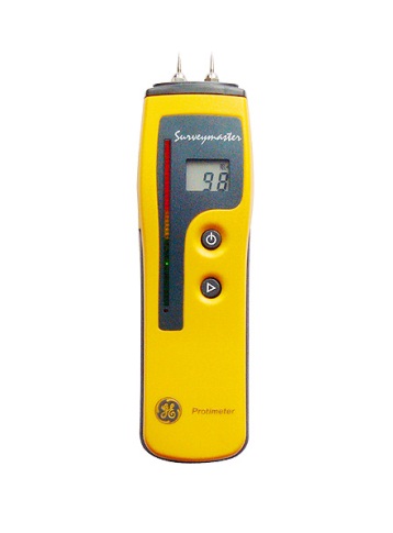
Protimeter Survey Master
$995 NZDA Dual Mode Moisture Meter For Sub-Surface And Surface Moisture Measuring
Protimeter Surveymaster is a dual mode moisture meter which allows the user to distinguish between sub-surface and surface moisture. Essential information when trying to establish the extent and cause of a dampness problem.
Features and Benefits:
- Durable and rugged design.
- Measure mode - Direct two-pin measure %WME.
- Search mode - Non-invasive measuring - no pin marks left.
- Detects moisture directly in materials.
- Detects moisture below wall / floor coverings (tile, wood, vinyl).
- Dual Display LCD and LED.
- Color changing LED’s to show moisture condition.
- Reset reading for sensitivity adjustment.
- Not adversely affected by surface moisture such as condensation.
The Protimeter Surveymaster incorporates two modes of operation - Measure and Search. This combination enables the user to distinguish surface moisture from sub-surface moisture, essential information when trying to establish the extent and cause of a dampness problem.
Measure Mode:
Utilising the two-pins at the top of the instrument, a direct reading of the moisture level can be read. The numerical values displayed in the LCD display represent the actual percent moisture content of wood (% MC) and the wood moisture equivalent (WME) of concrete, dry wall and other materials.
Optional hammer electrode and deep wall probes can be used with the Mini to measure the moisture level at depths in walls and floors, regardless of the surface condition. These options are useful accessories when investigating the cause of moisture problems within buildings.
Search Mode (Non-Invasive):
Measures moisture beneath the surface without drilling holes to a nominal depth of 0-20mm. Hold against the wall to allow a radio signal to penetrate the surface. This is the best method for assessing the moisture content beneath a tiled / covered surface. The relative moisture level of the material under investigation on a scale of 0-999.
Digital Readings:
The Protimeter Surveymaster features two displays that are synchronized, a digital LCD display supported by a colour-coded LED scale.
The LCD display shows the digital readings for both the measure and search modes. The colour coded LED scale indicates the material’s moisture condition, helping to support the readings. This provides a very simple way to determin if the readings are Dry, Borderline and Damp.
Protimeter Survey Master Specifications
- Pin Measurement Range: 7% to 99% WME
- Non-Invasive Range: 0 - 999 REL (relative)
- Depth of Measurement: Non-invasive up to 19 mm
- Depth of Measurement: Pin up to 12.7 mm
- Display 1: Digital LCD display
- Display 2: 60 LEDs-green(dry)yellow(at risk)red(wet)
- Power: 9V battery (included)
- Weight: 100g
- Dimensions (mm): 175 x 30 x 48
Product Downloads Section
Protimeter Surveymaster Moisture Meter
Protimeter Surveymaster is a dual mode moisture meter which allows the user to distinguish between sub-surface and surface moisture. Essential information when trying to establish the extent and cause of a dampness problem.
Protimeter Survey Master
Please contact us for more details on product rental.
Free Call: 0800-867-266
Phone: +64-9-476-5151
Email: info@synergypositioning.co.nz