
Products
- Machine Control
- GNSS Equipment
- Total Stations
- Lasers and Levels
- Aerial Mapping Systems
- Measuring Instruments
- Software
- Field Controllers
- Topcon Laser Scanning
- FARO Laser Scanning
- Mobile Mapping
- Hydrographic Survey Equipment
- Survey Accessories
- Lighting Systems
Your enquiry
Your rental enquiry
- Home
- Products
- Measuring Instruments
- Electronic Distance Meters
- Leica Distos
Leica Distos
The Leica Distos are Laser Measuring tapes used for applications that require quick accuate distance measurement. Simply point the laser beam at your target and press the measure button. They can measure up to 200m and have accuracies up to 1mm. Features include distance and angle measurement, tilt sensor, colour screen, bluetooth, area and volume calculations.
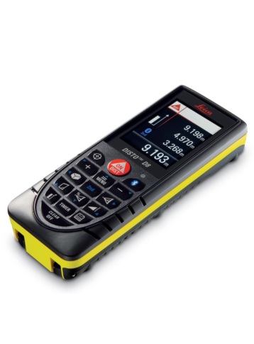
Leica Disto D8
The most versatile laser distance meter in the world! Equipped with a digital Pointfinder, high-resolution 2.4“ colour display, 360° tilt sensor and bluetooth® technology, the Leica DISTO™ D8 is a real world first and offers completely new measuring options.
- Digital Pointfinder with 4x zoom.
- Large colour display screen (2.4 inches).
- 360° Inclination measurement.
- Bluetooth® - reliable data transfer.
- DISTO™ transfer software and AutoCAD® plug-in included.
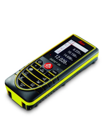
Leica Disto D5
World First: First laser distance meter with digital Pointfinder (4x zoom), large 2.4“ color display and ± 45°tilt sensor is now available!
The Leica DISTO™ D5 is designed with many functions and features to make measuring easier, particularly when you are working outdoors.
- Digital Pointfinder with 4x zoom.
- Large colour display screen (2.4 inches).
- Inclination measurement up to ± 45°.
- Power Range Technology™.
- Robust with IP 54.
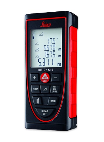
Leica Disto X310
The Leica DISTO™ X310 is the only laser distance meter to be dust-tight and protected against water jets – to IP65.
In addition, it passes drop tests of up to 2 m height. Thanks to the integrated tilt sensor, it can take indirect distance and height measurements absolutely precisely.
Leica DISTO™ X310 – guarantees reliable measurements, even under the harshest conditions.
- IP65 water jet protection and dust-tight.
- 360° tilt sensor.
- Smart Horizontal Mode™.
- Height tracking.
- Power Range Technology™.
- Illuminated 4-line display.
- Automatic multifunctional end-piece.
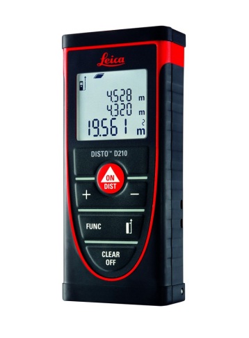
Leica Disto D210
New: The compact and handy entry-level model has many interesting functions and is still simple to use. Addition and subtraction, area and volume calculations for rapid and reliable site measurement. The last 10 results are stored.
Leica DISTO™ D210 – leave the measuring tape behind.
- Power Range Technology™.
- IP54 dust and water splash protection.
- Illuminated 3-line display.
- Automatic multifunctional end-piece.
Leica Disto D8 Specifications
- Inclination Measurement: 360°
- Display Screen: 2.4 inches (large color display)
- Digital Pointfinder: With 4x zoom
- Reliable Data Transfer: Bluetooth
- Robust: With IP 54
Leica Disto D5 Specifications
- Inclination Measurement: Up to ± 45°
- Display Screen: 2.4 inches (large color display)
- Digital Pointfinder: With 4x zoom
- Reliable Data Transfer: Bluetooth
Leica Disto X310 Specifications
- Tilt Sensor: 360°
- Robust: IP65 water jet protection and dust-tight
- Display: Illuminated 4-line display
- Technology: Power Range Technology
- End-Piece: Automatic multifunctional end-piece
Leica Disto D210 Specifications
- Robust: IP54 dust and water splash protection
- Technology: Power Range Technology
- Display: Illuminated 3-line display
- End-Piece: Automatic multifunctional end-piece
Product Downloads Section
Leica Distos
Please contact us for more details on product rental.
Free Call: 0800-867-266
Phone: +64-9-476-5151
Email: info@synergypositioning.co.nz