
Products
- Machine Control
- GNSS Equipment
- Total Stations
- Lasers and Levels
- Aerial Mapping Systems
- Measuring Instruments
- Software
- Field Controllers
- Topcon Laser Scanning
- FARO Laser Scanning
- Mobile Mapping
- Hydrographic Survey Equipment
- Survey Accessories
- Lighting Systems
Your enquiry
Your rental enquiry

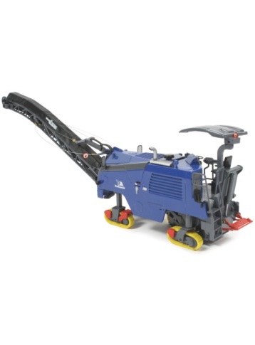
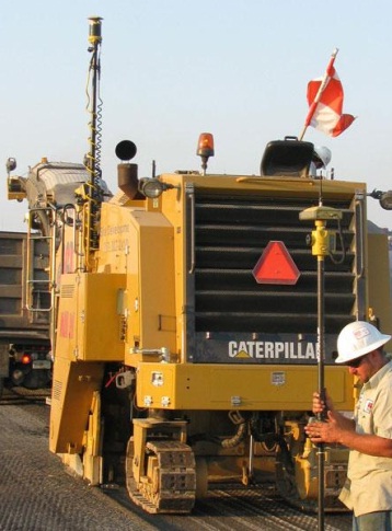
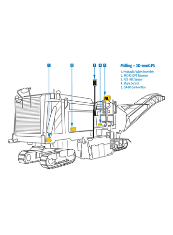
Topcon 3D Millimeter GPS System for Milling
Topcon's Millimeter GPS System is the World's First GPS based millimeter accurate control for milling machines. Topcon's revolutionary Lazer Zone™ technology based, Millimeter GPS uses GPS positioning together with a zone laser reference to give you unparalleled freedom and productivity. Topcon’s Millimeter GPS Milling has the simplicity of a laser, accuracy of a robotic total station, and multiple user capabilities of GPS.
Features & Benefits:
- High accuracy LaserZone™ covers the entire project.
- Provides precise vertical measurement for multiple machines and grade checkers.
- Use up to four transmitters to extend work area.
- Pave transitions,even through horizontal and vertical curves
- Works with existing Topcon GPS+ systems.
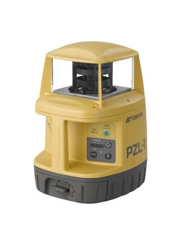
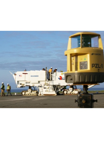
PZL-1
Positioning Zone Laser Transmitter operates similar to a standard rotating laser, but transmits a unique Lazer ZoneTM signal to provide a working range of 2000ft! Instead of a traditional flat plane, the PZL-1 provides an incredible measuring area of 33ft in height! You can even link up to four laser transmitters for use on large sites to cover a distance of nearly 8000ft with elevation changes of over 130ft! No more taking time out to reposition your laser. With the PZL-1, multiple machines can use the same transmitter, even at different elevations for continuous production!
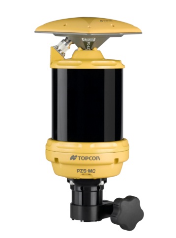
PZS-MC
The PZS-MC (Positioning Zone Sensor – Machine Control) mounts to your paver in the same manner as traditional laser receivers. Unlike traditional laser receivers, the PZS-MC knows it’s exact position within the 33’ vertical working range of the PZL-1 at every moment. With its integrated GPS antenna, the PZS-MC antennas continuously and accurately provide elevation and horizontal position information to the Control Box containing the digital site plans.
High Accuracy
Using the mmGPS LaserZone™ transmitters for Vertical referencing the 3D milling system holds a high degree of accuracy in all applications. Strategic placement of the mmGPS transmitters allows the entire project to be covered by mmGPS.
Precise Vertical Measurements
Eliminate any vertical fluctuation of GPS by using mmGPS LaserZone™ technology. The transmitters lock in the elevation on both the machines and the survey rovers to eliminate fluctuation and provide vertical data that will match not only from machine to machine, but from machine to rover.
Multiple Transmitters
By using up to four mmGPS transmitters the entire project can be covered. This features allows for continuous operation on both the machines and the survey rovers. Cover up to 2000' of highway or surround a job site with mmGPS transmitters to eliminate downtime and ensure accurate elevation control throughout.
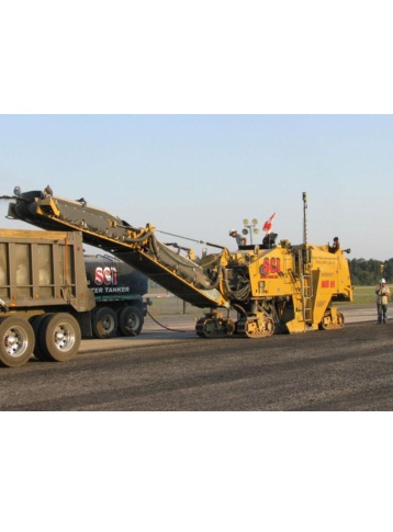
Mill Transitions
Joint matching? Vertical Curve? Horizontal Curve? No problem with mmGPS! Using a 3D design file to control the machine all the transitions are accounted for and will be precisely constructed. They can be verified with mmGPS on the survey rover for quality control.
Uses Existing Components
The mmGPS system uses all the same main components as other 3D Machine Control Systems. Simply add in the precise vertical control with mmGPS and you have a true plug and play system! The same main components can be swapped from machine to machine to us on all machine types. 3D Dozer system one day, 3D mmGPS milling machine the next!
9169 ( GX-60 ) Electrical Specifications
- Supply Voltage: 10-30VDC
- Supply Current: 3A Typical operating current
- Switched Output Power: 5A Sensor/Conditioned output power
- Ports: USB (2), RS-485, RS-232 , CAN(2)
9169 ( GX-60 ) Physical Specifications
- Display Panel: 640x480 Color VGA
- Housing: Cast aluminum
- Audio: 1ea environmentally sealed speaker
- Switches: 2 ea momentary pushbutton
- Connectors: 2 ea 19 socket MIL-C-5015
- Cooling: 1ea internal processor fan
- Weight: 6 lbs.
9169 ( GX-60 ) Environmental Specifications
- Operating Temperature: -20°C to +60°C
- Humidity: Mil Std 810D, method 506
- Shock Rating: 50G 11ms 1?2 sine wave each axis
- Vibration Rating: 10-400Hz sweep 5G, 1 oct/min
- Salt Fog Test: 48 Hours (ASTM B117-97)
PZL-1 Laser Transmitter Specifications
- Zone Width: ±10° (5~30m), ±5m (30~300m)
- Zone Radius: 300m(985ft)
- Laser Zone Accuracy: Vertical: 1 arc second resolution
- Auto-leveling range: ±3°
- Rotation Speed: 600rpm
- Laser Class: Class 2
- Light Source: L.D.
- Channels: 3
- Plummet: Yes
- Serial Port: RS-232C
- Power Supply: Ni-MH with runcharge
- Operating Time: Approx. 15 hours
- Operating Time at 20°C: Approx. 20 hours
- Ingress Protection: IPX6
- Operating Temperature: -20°C to +50°C
- Dimensions: 186(W) x 201(D) x 282(H) mm
- Weight: Approx. 2.9kg
- Bluetooth Transmission: Class2
- Bluetooth Communication Dist.: About 5m
PZS-1 Laser Receiver Specifications
- Detective Angle: ±10° Vertical ; ±10° Horizontal
- Serial Port: RS-232C
- Power Supply: BT-62Q
- Operating Time at 20°C: Approx. 8 hours
- Operating Temperature: -20°C to +50°C
- Ingress Protection: IPX6
- Dimensions: 170 (W) x 86 (D) x 144 (H) mm
- Weight: Approx. 1 kg
BC-30 Battery Specifications
- Input Voltage: AC-120V or 230V
- Recharging Time: Approx. 3 hours
- Operating Temperature: +10°C to +40°C
PZS-MC Machine Control Sensor Specifications
- Detective Angle: ±360° Horizontal; ±10° Vertical
- Power Supply: DC8V~DC32V
- Operating Temperature: -20°C to +50°C
- Ingress Protection: IPX6
- Dimensions: 180(W) x 180(D) x 322(H) mm
- Weight: Approx. 3 kg
MAGNET Office Software Product Specifications
- Operating System: Microsoft Windows XP, Vista, 7 and 8
- Processor Speed: 2GHz Core2 processor or higher
- RAM: 2GB RAM
- Memory: 512 MB minimum
- Ports: USB2 port for USB key
- Computer Resolution: 1280x1024 display resolution
Product Downloads Section
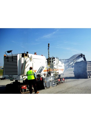
Topcon Millimeter GPS Product Line Profiler
See how Wiregrass Construction was able to meet tight specs for runway repaving job at Huntsville International Airport in Huntsville, Alabama using Topcon’s Millimeter GPS Profiling systems.
Topcon 3D Millimeter GPS System for Milling
Please contact us for more details on product rental.
Free Call: 0800-867-266
Phone: +64-9-476-5151
Email: info@synergypositioning.co.nz