
Products
- Machine Control
- GNSS Equipment
- Total Stations
- Lasers and Levels
- Aerial Mapping Systems
- Measuring Instruments
- Software
- Field Controllers
- Topcon Laser Scanning
- FARO Laser Scanning
- Mobile Mapping
- Hydrographic Survey Equipment
- Survey Accessories
- Lighting Systems
Your enquiry
Your rental enquiry
- Home
- Products
- Hydrographic Survey Equipment
- Single Beam Echo Sounders
- CEE HydroSystems CEESCOPE-USV
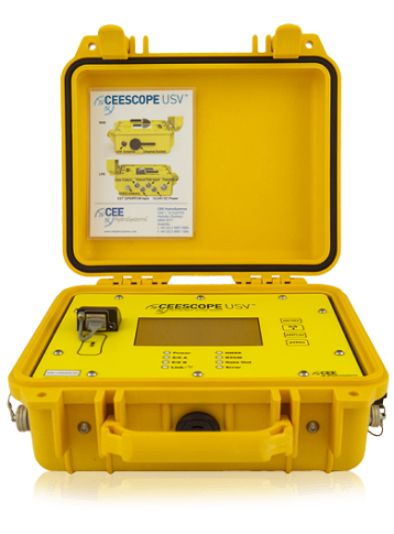
CEE HydroSystems CEESCOPE-USV
CEESCOPE-USV™ is a unique single or dual frequency hydrographic surveying system with GNSS positioning, echo sounding, data recording, and data telemetry in a single compact package for use on remotely-operated or autonomous survey boats.
The CEESCOPE-USV™ is a complete single beam hydrographic survey, GNSS and data radio telemetry package that can be installed on practically any Unmanned Surface Vessel (USV) or remote controlled survey boat. As a self-contained system requiring no data interface with the vehicle, USV instrument integration challenges are completely eliminated, and the vehicle design requirements can be simplified, lowering the total system cost. Using real time broadband radio telemetry, the USV operator on shore can view all bathymetry data via the CEE LINK™ radio module, including third party data such as video and side scan imagery.
The system can form the backbone of a remote hydrographic survey capability, with the reassurance that all of the components have already been tested and successfully used on USVs for several years. With rigorous handling of data timing and long range transmission with no interference issues, the echo sounder may be deployed on any vessel – from a surf board to a catamaran raft to a high power monohull.
The CEESCOPE-USV™ may be used interchangeably on a remote vehicle or manned boat. Simply connect the acquisition PC to the CEESCOPE-USV™ directly by LAN cable or WiFi and perform traditional bathymetric surveys. For use on a USV, instead connect the acquisition PC to the CEE LINK™ shore radio module that automatically receives data from the CEESCOPE-USV™ installed on the remote survey vehicle.
Precision Bathymetry: High Quality Shallow Water Hydrographic Surveys
CEESCOPE-USV™ offers the same exceptional shallow water performance as the CEE ECHO™ and CEESCOPE™ echo sounders. With bottom tracking in as little as 15 cm (6″) of water, the system is ideal for inshore USV surveys in rivers and ponds where a high proportion of the survey area may be too shallow for a manned boat. In addition, the CEESCOPE-USV™ records and transmits a water column echogram to the acquisition PC, offering detailed surveys with accurate results even in challenging environments.
Simplify Your Operation: Less Is More
Since 2011, CEE HydroSystems has been supplying compact echo sounders for USV deployment; we learned that mobilizing and setting up a USV with its various instruments and telemetry components might represent a significant portion of the total survey duration, and the overwhelming majority of the frustration. By putting all of the constituent parts (bathymetry, GNSS position, data multiplexing, and telemetry) into a single component: the CEESCOPE-USV™, many of the integration problems disappear. Simply turn on the CEESCOPE-USV™ echo sounder and survey data start being recorded; as soon as the CEE LINK™ shore radio module is powered-up and within range, data streams to the shore. Simply connect a data acquisition PC to start collecting data. The CEESCOPE-USV™ critical success factors for USV design and operation include:
Easy to operate.
The USV should be a survey tool and not a science project.
Easy to integrate external GNSS.
The CEESCOPE-USV™ will take in external position data with practically no changes in setup needed.
High quality shallow water bathymetry data – critical for USV operation.
The 200 kHz CEESCOPE-USV™ is able to maintain accurate bottom tracking in <15 cm (6″) water depth.
No latency.
The CEESCOPE-USV™ uses 1PPS GNSS time tags on all data collected, eliminating detrimental effects from radio transmission.
Field serviceable.
The CEESCOPE-USV™ design allows a greater safety factor for critical components, such as radio modules.
ON USV: CEESCOPE-USV™ echo sounder
- Channel: Dual channel echo sounder
- Built in GNSS receiver: Yes
- Internal battery: Yes
- WiFi: Long range WiFi telemetry
- Data logging: On board
- External input for third party data: Yes
ON SHORE: CEE LINK™ WiFi Telemetry Module
- Battery life indicator: Yes
- Waterproof: Yes
- Several antenna options: Yes
- Battery: 10 hr+ internal rechargeable battery
- Output: Ethernet output to hydrographic software
- WiFi link: To CEESCOPE-USV™
Product Downloads Section
CEE HydroSystems CEESCOPE USV Remote Survey Boat Echo Sounder and GPS
The CEESCOPE-USV is a unique single beam echo sounder and GPS survey package for remotely operated survey boats (USVs). Able to operate independently of the USV as a self contained unit, the CEESCOPE-USV is convenient for use either on a USV or a manned boat. The system offers a drastic reduction in complexity of operation compared to USV payloads based on several interconnected devices.