
Products
- Machine Control
- GNSS Equipment
- Total Stations
- Lasers and Levels
- Aerial Mapping Systems
- Measuring Instruments
- Software
- Field Controllers
- Topcon Laser Scanning
- FARO Laser Scanning
- Mobile Mapping
- Hydrographic Survey Equipment
- Survey Accessories
- Lighting Systems
Your enquiry
Your rental enquiry
- Home
- Products
- Hydrographic Survey Equipment
- Single Beam Echo Sounders
- CEE HydroSystems CEESCOPE
CEE HydroSystems CEESCOPE
CEESCOPE™ is a state of the art portable hydrographic surveying system with advanced capabilities in a truly compact package.
Coupling powerful built-in RTK GNSS with a survey grade echo sounder in a single waterproof enclosure, it represents the ultimate in shallow water single beam survey systems.
Survey grade echo sounder data including a full water column echo envelope are combined with GNSS position in a simplified and easy to use one-box solution for hydrographic surveying. On-board GNSS receiver options from Trimble, Hemisphere, and NovAtel provide flexibility to meet varying survey and budget requirements. The CEESCOPE™ RTK includes a built-in RTK GNSS and UHF radio modem, allowing incorporation into existing RTK base station networks with no additional hardware on the survey boat.
Trust Your Data: See Exceptional Detail In High Definition
The CEE ECHO™ and CEESCOPE™ echo sounders can log soundings at up to 20 Hz, providing exceptional bottom detail along the survey track. In addition to the sounding depth output, the complete sonar echo return from each ping is digitized into 3200 separate and discrete values from just below the surface to the sub-bottom level. The intensity of the echo return from the entire water column and sub-bottom is recorded, not just the single sounding depth value for each ping. When it comes to reviewing data quality in real time and after the survey is completed, the echogram record presents a crucial advantage over basic echo sounders that output only the digital depth sounding value. For example, heavy bottom vegetation may be identified on the echogram and differentiated from the true bottom, a process that may be impossible with a basic echo sounder.
A Complete One-box Solution: Convenience And Performance
With the CEESCOPE™, the surveyor can simply get on with the job of collecting accurate bathymetry. The ultimate CEESCOPE™ package includes an RTK GNSS receiver and Satel UHF radio modem, all in a compact portable one-box package. Connection to a local base station is possible without the need for any additional hardware in the field, minimizing the setup time, eliminating radios, cables and batteries. Just turn on and start surveying!
All of the CEESCOPE™ functions may be accessed through an LCD touch screen, and CEE CONNECT control software utility, making the unit setup and configuration easy. For surveying when a laptop is not desired, such as on a personal watercraft, the internal memory or an external USB flash drive can be used to record the entire survey – including the full water column echogram.
Precision GNSS: No Compromise Position Data
The CEESCOPE™ can be specified with the latest OEM GNSS options from NovAtel, Hemisphere GPS, and Trimble to ensure all accuracy requirements are met. For surveying at the submeter level, a range of receiver options provide 0.1 – 0.5m accuracy, with optional L-Band corrections for survey locations without SBAS service. RTK positioning is available for users requiring cm-level accuracy or GNSS elevation (tide) data. The use of 1 pulse per second (PPS) timing from the on-board GNSS receiver offers precise time stamping for the complete dataset collected by the CEESCOPE™. This ensures all soundings taken between GNSS location updates are accurately positioned.
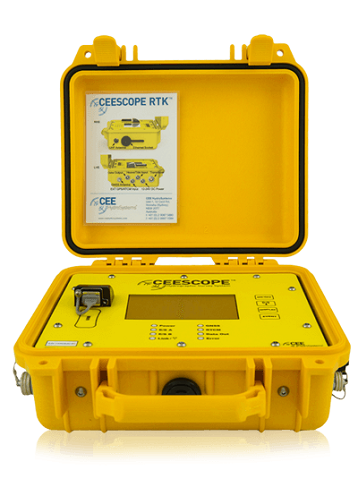
Physical
- Dimensions: 30.0 x 25.0 x 13.8 cm (L x W x D)
- Display: 420 x 272 touch screen colour LCD
- Weight: 3.65 kg
- Colour: Pelican Yellow
- Connectors: LEMO 1K & 2K series, Industrial RJ45, Industrial USB
Environmental
- Operating temperature: 0°C – 50°C
- Humidity: 95% non condensing
- Ingress protection rating: IP67
Power
- Internal battery: Rechargeable high capacity NiMH battery 10Ah
- Antenna voltage output: 5.0 VDC
- External power supply: Nominal 12.0 VDC @ 2A (9-24 VDC range)
- Power supply: Nominal 5.0 VDC @ 100 mA (5-24 VDC range)
Data Logging
- Internal memory: 16 GB (32 GB optional)
- External memory: 16 GB (32 GB optional)
Echosounder
- Mode: Automatic and Manual
- Resolution: 1 cm
- Transducer draft setting: 0 – 10 m (1 cm increments)
- Index offset: 0 – 10 m
- Blanking: 7 – 500 cm
- Ping rate: 1-20 Hertz
- TVG: None, LOG 10, LOG 20
- Manual gain: 30 – 100%
- Detection threshold: 10 – 50%
External Data Interfaces
- GPS input : NMEA 0183
- Heave input: TSS 1
- Tide input : CEETIDE
- Baud rate : 4800 – 115200
- Data bits/parity/stop bits: 8/N/1
Product Downloads Section
CEE HydroSystems CEESCOPE RTK - Amazing Simple Setup in 4x Motion - Single Beam Echo Sounder
See what it takes to set up a small hydrographic survey boat when using the CEE HydroSystems CEESCOPE™, in 4x fast motion. With an RTK receiver inside the waterproof CESCOPE™ set to receive corrections from a local base station, along with an internal battery and dual channel echo sounder, simply connect the Ethernet cable to the acquisition PC, start HYPACK® and start surveying. Ideal for traveling light for surveys in remote areas. Or to eliminate the spaghetti of wires and USB dongles from your surveys.
CEE HydroSystems CEE ECHO™ versus BASIC Echo Sounders - All SBES are not the Same
All echo sounders are not the same. Avoid reporting false data in challenging environments by relying on the CEE HydroSystems CEE ECHO™ or CEESCOPE™ with full water column echogram for sounding quality control. Using HYPACK or the latest Hydromagic software allows exceptional detail and quality control when using these versatile single beam echo sounders.