
Products
- Machine Control
- GNSS Equipment
- Total Stations
- Lasers and Levels
- Aerial Mapping Systems
- Measuring Instruments
- Software
- Field Controllers
- Topcon Laser Scanning
- FARO Laser Scanning
- Mobile Mapping
- Hydrographic Survey Equipment
- Survey Accessories
- Lighting Systems
Your enquiry
Your rental enquiry
- Home
- Products
- Hydrographic Survey Equipment
- Single Beam Echo Sounders
- CEE HydroSystems CEE-LINE
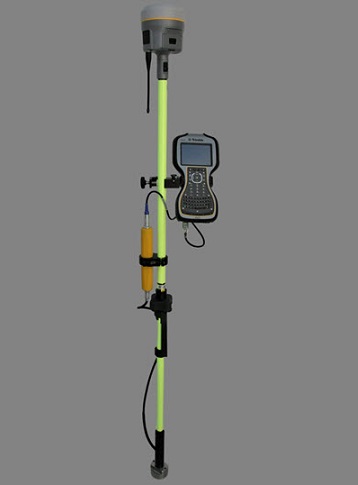
CEE HydroSystems CEE-LINE
CEE-LINE™ brings hydrographic-grade performance to bathymetry projects using land survey data acquisition.
Indestructible with exceptional sounding consistency, simply connect the CEE-LINE™ to a data collector, tablet or PC for accurate and trustworthy results.
The CEE-LINE™ represents a next generation approach to GNSS pole-mounted bathymetry surveys. With an indestructible construction and a no-nonsense USB power cable connection to the acquisition data collector, tablet or PC the CEE-LINE™ is a survey-grade echo sounder designed for maximum reliability and exceptional bottom tracking. With no internal battery to worry about, the CEE-LINE™ is always ready to start surveying.
Containing a super-fast modern processor running advanced bottom tracking algorithms, the CEE LINE™ keeps a solid lock on the bottom even in extremely shallow water. With a ping rate up to 10Hz and two frequency channels 33 kHz and 200 kHz available, the CEE LINE™ may equally be used with dedicated hydrographic acquisition software or with GNSS topographic acquisition utilities.
Ultra-Modern Processing Unit
The CEE-LINE™ echo sounder uses a 2016 generation small form factor processor to run complex bottom tracking algorithms while maintaining a high ping rate, maintaining a rock-steady lock on the “real” bottom and ignoring fake signals such as double reflections and unwanted noise. With flexibility to use several different transducers and even operate in dual frequency 33/200 kHz mode, the CEE-LINE™ is a true hydrographic survey quality performer whether used with a GNSS data collector or with an acquisition PC running HYPACK®.
Hydrographic Quality Narrow Beamwidth Transducers
All CEE echo sounders use hydrographic survey-grade analog transducers, including the CEE-LINE™. This means the depth sounder calculations are performed in the CEE-LINE™ processor module and not in the transducer itself as happens in so called “smart” echo sounders.
Flexible Solution for All Data Acquisition Methods
The CEE-LINE™ is designed to operate with hand controllers using either a USB or COM port interface. Simply plug the data / power cable into the acquisition device and bring in the echo sounder depth data. The CEE-LINE™ outputs several formats for trouble-free integration into GNSS continuous topo data recording.
Compatible With GNSS Acquisition Software
The CEE-LINE™ can be used with practically all GNSS data collection equipment. Whether you are replacing an existing pole-mounted echo sounder or introducing a new hydrographic capability for inshore bathymetric surveys, the CEE-LINE™ can be trusted to work seamlessly with common acquisition utilities such as Trimble Survey Controller, Trimble Access, Carlson SurvCE, Topcon MAGNET Field, and Leica Viva. The CEE-LINE™ continuously streams accurate depth data every tenth of a second, ready to be incorporated into the GNSS topographic dataset as a modified point elevation.
No Battery Required: USB Connectivity
The USB smart cable offers a simple and reliable data and power interface with the CEE-LINE™. No need to worry about charging batteries or dealing with potentially troublesome Bluetooth interface settings, or having to use a potentially unreliable wireless connection. Every time the CEE-LINE™ is plugged in, it is ready to start work. With a low power draw – especially working in shallow water – battery run time on a connected data collector will not decrease excessively even with the acquisition device powering the CEE-LINE™.
Rugged and Durable
Manufactured to exceptional quality standards with an encapsulated processor core and an over-molded jacket the CEE-LINE™ will withstand years of field work plus more extreme abuse. Even complete immersion under water or a 6ft+ drop on concrete will have no effect on the CEE-LINE™ operation. Don’t introduce a weak link in your survey equipment – choose the CEE-LINE™.
Minimalist Design
By reducing the connections to just two waterproof LEMO plugs (transducer, and power / data) the CEE-LINE™ has no weak points, less to go wrong, and nothing to break off.
General Surveys
- Frequency: 200kHz
- Beam Width @-3dB: 9 deg
- RMS Power: 500 W
- Q: 2
- Cable Length: 0.3-9m
- Weight: 1.3 kg
- Housing Material: Stainless Steel
- Acoustic Window: Urethane
Engineering Surveys
- Frequency: 200kHz
- Beam Width @-3dB: 3 deg
- RMS Power: 3 kW
- Q: 6.5
- Cable Length: 0.3-10 m
- Weight: 5.5 kg
- Housing Material: Stainless Steel
- Acoustic Window: Urethane
Dual Frequency
- Frequency: 33 / 200 kHz
- Beam Width @-3dB: 26 deg / 9 deg
- RMS Power: 500W / 500W
- Q: N/A
- Cable Length: 0.3-11 m
- Weight: 3.6 kg
- Housing Material: Cast Urethane
- Acoustic Window: Urethane