
Products
- Machine Control
- GNSS Equipment
- Total Stations
- Lasers and Levels
- Aerial Mapping Systems
- Measuring Instruments
- Software
- Field Controllers
- Topcon Laser Scanning
- FARO Laser Scanning
- Mobile Mapping
- Hydrographic Survey Equipment
- Survey Accessories
- Lighting Systems
Your enquiry
Your rental enquiry
- Home
- Products
- Hydrographic Survey Equipment
- Single Beam Echo Sounders
- CEE HydroSystems CEE ECHO
CEE HydroSystems CEE ECHO
CEE ECHO™ is a state of the art portable echo sounder with advanced capabilities in a truly compact package.
Internal data logging, full water column echogram and 20 Hz ping rate in a robust waterproof enclosure proves quality does not have to be sacrificed for convenience.
Able to interface with an external GNSS or GPS receiver, the CEE ECHO™ brings position and echo sounder data together to offer a greatly simplified and elegant survey solution. Using modern miniaturized electronic components throughout, sonar performance matches larger traditional echo sounder designs. The CEE ECHO™ is a small, portable, rugged and waterproof single beam echo sounder for use on practically any survey boat from a kayak to a dedicated coastal hydrographic survey vessel.
Trust Your Data: See Exceptional Detail In High Definition
The CEE ECHO™ and CEESCOPE™ echo sounders can log soundings at up to 20 Hz, providing exceptional bottom detail along the survey track. In addition to the sounding depth output, the complete sonar echo return from each ping is digitized into 3200 separate and discrete values from just below the surface to the sub-bottom level. The intensity of the echo return from the entire water column and sub-bottom is recorded, not just the single sounding depth value for each ping. When it comes to reviewing data quality in real time and after the survey is completed, the echogram record presents a crucial advantage over basic echo sounders that output only the digital depth sounding value. For example, heavy bottom vegetation may be identified on the echogram and differentiated from the true bottom, a process that may be impossible with a basic echo sounder.
Survey Grade Results: Advanced Echo Sounder Processor
Set the echo sounder to “Auto” or “Shallow” mode and the robust bottom tracking algorithms will manipulate the sonar pulse width and gain to keep a solid lock on the bottom with the minimum of operator involvement, even in very shallow water. The use of precise GNSS-derived time stamps for the complete dataset collected by the CEE ECHO™ ensures all soundings are accurately positioned. By routing all position data from the external GPS receiver to the CEE ECHO™, the system offers the flexibility to record a complete dataset with no connected PC and simplifies the data collection process when using hydrographic acquisition software.
Minimize Setup Time: Modern Simple User Interface
Just turn on and start surveying! All of the functions of the CEE ECHO™ may be accessed through the LCD touch screen interface and CEE CONNECT control software utility, making the unit setup and configuration easy. For surveying when a laptop is not desired, such as on a small boat or personal watercraft, internal memory or an external USB flash drive can be used to record the entire survey including the full water column echogram.
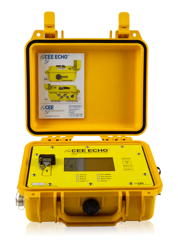
Physical
- Dimensions: 30.0 x 25.0 x 13.8 cm
- Display: 420 x 272 touch screen colour LCD
- Weight: 3.52 kg
- Colour: Yellow
- Connectors: LEMO 1K & 2K Series, Industrial RJ45
Environmental
- Operating temperature: 0°C – 50°C
- Humidity: 95% non condensing
- Ingress protection rating: IP67
Power
- Power consumption: 6.8 watts
- Internal battery: Rechargeable high capacity NiMH battery 10Ah
- Power supply: Nominal 12.0 VDC @ 2A (9-24 VDC range)
Wireless Connectivity
- Bluetooth internal antenna: 0 - 50 m range
Data Logging
- Internal memory: 16 GB (32 GB optional)
- External memory: 16 GB (32 GB optional)
Echosounder
- Mode: Auto shallow, auto or manual
- Resolution: 1 cm
- Sound velocity : 1350 – 1750 m/s Resolution 1 m/s
- Transducer draft setting: 0 – 10 m (1 cm increments)
- Index offset: 0 – 10 m
- Blanking: 7 – 500 cm
- Ping rate: 1-20 Hertz
- TVG: None, LOG 10, LOG 20
- Manual gain: 30 – 100%
- Detection threshold: 10 – 50%
External Data Interfaces
- GNSS input: NMEA 0183
- Heave input: TSS 1
- Tide input : CEETIDE
Product Downloads Section
CEE HydroSystems CEESCOPE™ CEE ECHO™ Dual Frequency Echo Sounder in Shallow Water
Watch detailed sonar results from the CEE HydroSystems CEESCOPE™ single beam echo sounder (SBES) in very shallow water. Where some echo sounders become unreliable, the CEESCOPE™ family of "all in one" survey systems continue to provide accurate and detailed results right up to the water's edge. For surveying in rivers, lakes, reservoirs, or the coastal ocean, CEE HydroSystems has the solution: dredging, bathymetry, remediation.
CEE HydroSystems CEE ECHO™ versus BASIC Echo Sounders - All SBES are not the Same
All echo sounders are not the same. Avoid reporting false data in challenging environments by relying on the CEE HydroSystems CEE ECHO™ or CEESCOPE™ with full water column echogram for sounding quality control. Using HYPACK or the latest Hydromagic software allows exceptional detail and quality control when using these versatile single beam echo sounders.