
Products
- Machine Control
- GNSS Equipment
- Total Stations
- Lasers and Levels
- Aerial Mapping Systems
- Measuring Instruments
- Software
- Field Controllers
- Topcon Laser Scanning
- FARO Laser Scanning
- Mobile Mapping
- Hydrographic Survey Equipment
- Survey Accessories
- Lighting Systems
Your enquiry
Your rental enquiry
- Home
- Products
- Hydrographic Survey Equipment
- PPS Synchronization
- CEE HydroSystems CEESYNC
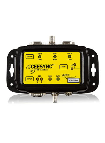
CEE HydroSystems CEESYNC
CEESYNC™ provides a high quality PPS splitting and synchronization solution for multibeam echo sounder installations, compatible with all industry standard GNSS receivers.
With DB9 and BNC inputs and dual DB9 outputs, the CEESYNC™ effectively splits and modulates the 1 pulse per second (1PPS) signal for multibeam echo sounder installations that require a modified or split pulse. The CEESYNC™ is a high quality replacement for weak-link components or cables.
Flexibility
The CEESYNC™ has a wide DC voltage input range and can be powered via a USB port on a PC for simplified installation. A simple membrane configures inputs and outputs. The unit features 9 LEDs to display current system status. The 1PPS pulse modulation as required by HYPACK® software is enabled, where the timing signal needs to be directly connected to the acquisition PC in addition to the echo sounder.
The 1 Pulse Per Second is an electrical signal that has a width of less than one second and a sharply rising or falling edge that accurately repeats once every second. The 1PPS signal is output by many GPS / GNSS receivers as derived from the precise GPS system time. This signal can be used to accurately time stamp data from multibeam echo sounders and single beam echo sounders such as the CEESCOPE™.
Ultimate Build Quality
Eliminate existing splitter cables or makeshift and low grade electronics components. The CEESYNC™ is manufactured to the same exacting standards as the rest of the CEE HydroSystems product range. In an indestructible enclosure with high quality connectors and membrane buttons with LED indicators, the CEESYNC™ ensures that there no longer needs to be a weak link in a multibeam echo sounder installation where PPS splitting is required.
Physical
- Dimensions: 18 x 9 x 4 cm
- Display: Status LEDs
- Weight: 450 g
- Colour: Black
- Connectors: BNC, DB9 and 2.5 mm power jack
Environmental
- Operating temperature: 0°C – 50°C
- Humidity: 95% non condensing
- Ingress protection rating: IP67
Power
- Power consumption: 0.3 watts
- Power supply: Nominal 5.0 VDC @ 100 mA
PPS Inputs
- User configurable: DB9 pin 8, DB9 pin 9 or BNC
Data Outputs
- DB9 1: Modulated PPS (pin 8)
- DB9 2: Modulated PPS (pin 8)
- BNC: Raw PPS pass through