
Products
- Machine Control
- GNSS Equipment
- Total Stations
- Lasers and Levels
- Aerial Mapping Systems
- Measuring Instruments
- Software
- Field Controllers
- Topcon Laser Scanning
- FARO Laser Scanning
- Mobile Mapping
- Hydrographic Survey Equipment
- Survey Accessories
- Lighting Systems
Your enquiry
Your rental enquiry
- Home
- Products
- Hydrographic Survey Equipment
- Jet Ski Survey Watercraft
- CEE HydroSystems CEE JET
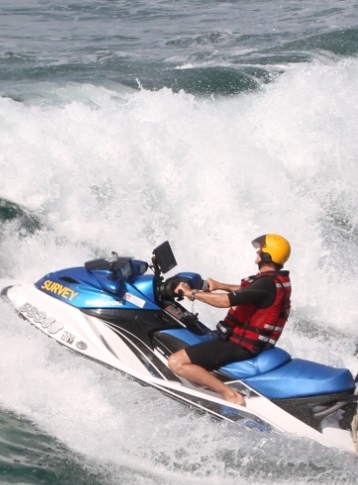
CEE HydroSystems CEE JET
CEE JET Personal Watercraft
The CEE JET™ is a fully integrated surf zone hydrographic survey system for professional grade results in challenging near shore environments, based on the “all in one” CEESCOPE™ echo sounder. All of the hydrographic system components are installed inside a modified water tight storage compartment. With an on-board computer and custom designed display and transducer mounting brackets, the CEE JET™ is a field-proven turnkey solution for the most challenging survey locations.
CEE HydroSystems CEE JET Specs
- On-board computer: Yes
- Custom designed display: Yes
- Transducer mounting brackets: Yes
Product Downloads Section
Jetski PWC Surfzone and Inshore Hydrographic Bathymetry Mapping with a CEESCOPE Echo Sounder
Environmental beach survey on Australia's East Coast.
CEE HydroSystems CEE-JET™ Jetski Hydrographic Survey System CEESCOPE RTK
Watch Macquarie University conduct single beam echo sounder bathymetry (SBES) surveys using the Sydney Institute of Marine Science jetski personal watercraft survey system. Based on an integrated "all in one" CEESCOPE-RTK echo sounder, the CEE-JET™ is a turnkey solution for challenging nearshore surveys. With no exposed cables or instrumentation, the CEE-JET™ is a rugged and reliable solution. With an on-board PC running HYPACK®, accessible through a waterproof mouse and monitor, high quality bathymetry may be collected without headaches of equipment failure.