
Products
- Machine Control
- GNSS Equipment
- Total Stations
- Lasers and Levels
- Aerial Mapping Systems
- Measuring Instruments
- Software
- Field Controllers
- Topcon Laser Scanning
- FARO Laser Scanning
- Mobile Mapping
- Hydrographic Survey Equipment
- Survey Accessories
- Lighting Systems
Your enquiry
Your rental enquiry
- Home
- Products
- Hydrographic Survey Equipment
- Hydrographic Survey Software
- CEE HydroSystems Eye4Software HYDROMAGIC
CEE HydroSystems Eye4Software HYDROMAGIC
Intuitive Single Beam Acquisition Software Package
Hydromagic is a professional hydrographic survey software package for the acquisition and editing of single beam echo sounder surveys. The software is affordable and has been designed to be intuitive, allowing new users with relatively little experience in hydrographic surveying to quickly become proficient and start conducting bathymetry projects. Most menus and settings are accessible from a simple right-click, and the entire package operates from a single menu view making navigation around the user interface easy. The geodetic framework of Hydromagic is rigorous, with over 5000 pre defined local and global map datums and grids available. Surveying with an RTK GNSS receiver providing tide (elevation) data in real time is possible using appropriate geoid models.
Eye4Software is based in the Netherlands, and specializes in developing GPS and GIS software for Windows. Eye4Software began developing hydrographic software in 2001 and started selling Hydromagic worldwide in 2011.
Hydromagic Features:
- Echo sounder and ancillary equipment drivers for many commonly used survey devices.
- Built-in map downloading tool. Download maps for the survey area using easy “one click” functions.
- Import geo-referenced maps in many common formats.
- Automatic (RTK) or manual tide correction.
- Heave, pitch and roll correction from motion sensors.
- High definition echogram recording and display.
- Data editing and filtering to convert raw data to sounding data files.
- Generate regularly spaced XYZ data (matrices) using Triangulation and Interpolation (TIN)
- Export edited sounding point cloud XYZ or matrices.
Simple and Clear Navigation Display
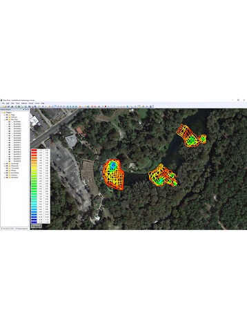
Hydromagic presents the bathymetry and position information in a simple, single window view that shows the GNSS and sounding data, vessel track and georeferenced colorized soundings. If survey lines have been loaded, a cross track error indicator is available to help steering down the survey line.
Single Beam Data Editing
Hydromagic has a range of data editing functions to convert raw data files into edited soundings. Tide and sound velocity corrections may be applied, and data may be edited and filtered based on position and depth data.
XYZ and Final Product Data Export
Edited data may be exported as an XYZ point cloud for processing in third party software. TIN modeling in Hydromagic may be used to generate matrices of equidistant point data that may then be used for contour plots and volume / cross section calculations. Several output formats are available for common industry software packages, including export to Google Earth.
Volume Calculation Tools
For industrial water management applications, Hydromagic has an automated strapping chart feature that allows a bathymetry map to form the basis of a water level versus volume relationship for a storage pond. Changes in measured water level may be easily converted to available water volume, and report templates are available for export.
Using Hydromagic with the CEESCOPE™ and CEE ECHO™ Echo Sounders
The CEESCOPE™ and CEE ECHO™ single beam echo sounders are supported with exceptionally user-friendly device drivers, developed by Eye4Software in close cooperation with CEE HydroSystems. Simply select the CEE device in the Hydromagic equipment menu and all of the required settings to collect data with these echo sounders are automatically uploaded, minimizing startup time and practically eliminating the opportunity for errors in software setup.
Dedicated Driver for the CEESCOPE™ and CEE ECHO™
When using Hydromagic software, the proprietary “CEE” output format is available to allow collection of the most precise and detailed sounding results in combination with the CEE device driver. The benefits of using the CEE proprietary data output instead of a standard single or dual frequency driver (eg. Odom SBT / DBT or Atlas DESO 25) are significant:
Record the Water Column Echogram
The full water column echogram is recorded as a binary (BIN) file in addition to the digitized RAW sounding data file. Hydromagic is able to acquire the full CEE water column echogram in high definition at 3200 samples per ping, at up to 20 pings/sec. This offers exceptional detail in the real time echo envelope view to ensure appropriate bottom tracking is maintained and the ability to identify features during editing that may need to be eliminated from the sounding data such as sub aquatic vegetation.
Use Time-Stamped Data
The special time-stamp inserted with every data packet inside the echo sounder is used for precise measurement timing instead of PC time, minimizing latency and maximizing accuracy. This feature is especially beneficial for operation on board USVs where data is telemetered to the shore and latency concerns are higher than in conventional manned boat applications.
CEE HydroSystems Eye4Software HYDROMAGIC Specs
- Exporting options: Vast number available
- Built-in 1: Map downloader
- Built-in 2: Filtering of singlebeam soundings
- Tide correction: Automatic using RTK
- Support: NADCON, HARN and NTv2 connection grids
Product Downloads Section
Hydromagic Training Video
Setting up the CEEPULSE and GPS.