
Products
- Machine Control
- GNSS Equipment
- Total Stations
- Lasers and Levels
- Aerial Mapping Systems
- Measuring Instruments
- Software
- Field Controllers
- Topcon Laser Scanning
- FARO Laser Scanning
- Mobile Mapping
- Hydrographic Survey Equipment
- Survey Accessories
- Lighting Systems
Your enquiry
Your rental enquiry
- Home
- Products
- Hydrographic Survey Equipment
- CEE HydroSystems CEETIDE
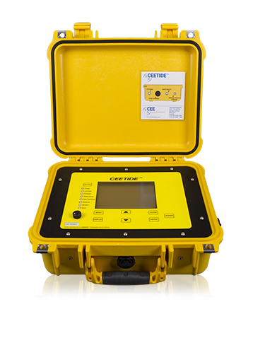
CEE HydroSystems CEETIDE
CEETIDE™ radar tide gauge recorder components are designed and manufactured to withstand the harsh marine environment.
And are enclosed in a virtually indestructible Pelican™ case to offer a resilient field solution for water level and meterological data recording.
The CEETIDE™ is a simple to install, extremely low maintenance and easy to operate radar tide gauge recorder that can accurately monitor tidal movements in a compact system. There are no moving parts or sensors submerged in water, reducing the amount of maintenance required to maintain an accurate tide gauge installation. The CEETIDE™ can either be permanently installed for port operations or can be used as a portable tide recorder requiring minimal setup.
Low Maintenance: Radar Water Level Sensor
The CEETIDE™ operates with a radar level sensor that eliminates issues associated with corrosion and fouling of submerged pressure sensors. The non contact probe makes installation easier and maximises flexibility of probe positioning. As the position of the radar sensor can be precisely and easily recorded, it makes the establishing of its position relative to the survey datum easy. Unlike submerged pressure measuring devices, the accuracy of the tide measurements are not affected by changes in water density and atmospheric conditions.
Rugged: For Maximum Reliability
High quality components and a weatherproof enclosure ensures data collection is not compromised by equipment failure.
Physical
- Dimensions: 36.5 x 29.5 x 15.5 cm
- Display: 320 x 240 Backlit LCD with contrast control
- Weight: 5.6 kg
- Colour: Pelican Yellow
- Connectors: LEMO 1B series, TNC (telemetry), CA 6+E
Environmental
- Operating temperature: 0°C-50°C
- Humidity: 95% non condensing
- Ingress protection rating: IP65
Power
- Power consumption: 1.8 watts (average)
- Internal battery: Rechargeable SLA Battery 7.0 Ah
- External power supply: Nominal 12.0 VDC @ 1A
Radar Probe Options
- Short range: 0.5-15 m
- Long range: 0.5-35 m
- Cable length: – options available
Logging
- Memory capacity (STD): 65,000 Tide readings (Flash memory)
- Extended memory (Opt): 16,500,000 Tide reading (Flash memory)
- Log interval: 1, 2, 5, 6, 10, 15, 20 or 30 minute/s
- Real time output interval: 5, 10, 15, 30 or 60 seconds
Telemetry Module Options
- UHF: Range 1-10 km
- VHF: Range 1-20 km
- GSM: Range network dependant
- HSPA: Range network dependant
- Bluetooth: Range 10-300 m