
Products
- Machine Control
- GNSS Equipment
- Total Stations
- Lasers and Levels
- Aerial Mapping Systems
- Measuring Instruments
- Software
- Field Controllers
- Topcon Laser Scanning
- FARO Laser Scanning
- Mobile Mapping
- Hydrographic Survey Equipment
- Survey Accessories
- Lighting Systems
Your enquiry
Your rental enquiry
- Home
- Products
- GNSS Equipment
- Topcon MR-2
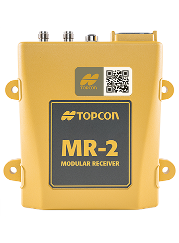
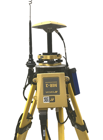
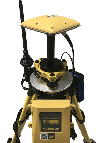
Topcon MR-2
Toughen up your Positioning Applications
Full constellation RTK positioning and heading determination with flexible connectivity.
Built to meet all your needs
The MR-2 combines futureproof full constellation tracking with HD2/Heading capabilities and a comprehensive set of communication interfaces. The MR-2 is able to track all present and upcoming GNSS constellations and satellite signals. With 8GB of internal storage and enhanced connection options including Serial, USB, CAN and Ethernet, the MR-2 is a versatile GNSS receiver suitable for any OEM application.
- 226 Universal Channel Vanguard Technology
- Simultaneous RTK positioning and heading determination
- Serial, USB, CAN and Ethernet connectivity
- 8GB internal memory
GNSS
- Channels: 226 with Universal Tracking Channel Technology
- Signals Tracked 1: GPS: L1 C/A, L1C, L1P(Y), L2P(Y), L2C, L5
- Signals Tracked 2: GLONASS: L1 C/A, L1P, L2 C/A, L2P, L3C
- Signals Tracked 3: Galileo: E1, E5a, E5b, E5AltBoc
- Signals Tracked 4: BeiDou: B1, B2
- Signals Tracked 5: SBAS Corrections: WAAS/EGNOS/MSAS
- Signals Tracked 6: QZSS: L1 C/A, L1C, L2C, L5C
- Signals Tracked 7: L-band: Yes (1525-1560 MHz)
- Antenna Type 1: External dual antenna input for heading
- Antenna Type 2: determination through Topcon HD2 technology
Accuracy
- RTK 1: H: 5 mm+ 0.5 ppm (x baseline length)
- RTK 2: V: 10 mm + 0.8 ppm (x baseline length)
- Static/Fast Static 1: H: 3 mm + 0.5 ppm (x baseline length)
- Static/Fast Static 2: V: 5 mm + 0.8 ppm (x baseline length)
- DGPS (RTCM): H: 0.3 m, V: 0.5 m
- SBAS: H: 0.8 m, V: 1.2 m
- Heading: 0.3°/D (D = inter-antenna distance in meters)
- Inclination: 0.5°/D (D = inter-antenna distance in meters)
- Velocity: 0.02 m/sec
- Time: 30 nsec
Data and Memory
- Internal Memory: Up to 8GB for each B125 board
- Data Update/Output Rate: Up to 100 Hz
- Real Time Data Output 1: Proprietary TPS format, RTCM SC104
- Real Time Data Output 2: ver. 2.x, 3.0 and 3.1; CMR/CMR+; MSM;
- Real Time Data Output 3: NMEA 0183 version 2.x, 3.0, and 3.01
- Heading Determination: Yes
Communications
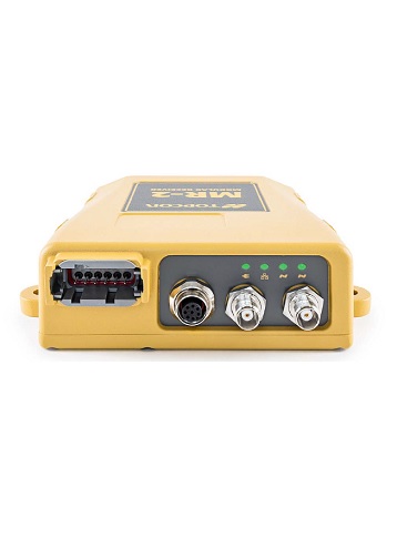
- Antenna Connectors: 2x TNC (Antenna power 4.75-5.10 VDC)
- Ports 1: Deutsch DTM Series 12-pin Receptacle for
- Ports 2 (continued..): power and communications, Serial (x3), CAN,
- Ports 3 (continued..): and PPS on main connector Turck M12 8-Pin
- Ports 4 (continued..): Breaks out to RJ45 and SAE power
Environmental
- Temperature 1: Operating: -40ºC to 75ºC
- Temperature 2: Storage: -50ºC to 85ºC
- Enclosure: Aluminum alloy
- Waterproof Rating: IPX7 (1 meter submersion)
- Dust Rating: IP6X (fully dust proof)
- Humidity: 100%, condensing
Power
- Internal Voltage Range: 9-36 VDC Reverse Polarity Protected
- Power Consumption: 10 W at 9-36 VDC
Physical
- Dimension (w x d x h): 172 x 166 x 49 mm
- Weight: 0.95 kg
- LED Indicators: Power, Ethernet, Primary Antenna, Secondary Antenna
Product Downloads Section
Topcon MR-2 Modular GNSS Receiver
Please contact us for more details on product rental.
Free Call: 0800-867-266
Phone: +64-9-476-5151
Email: info@synergypositioning.co.nz