
Products
- Machine Control
- GNSS Equipment
- Total Stations
- Lasers and Levels
- Aerial Mapping Systems
- Measuring Instruments
- Software
- Field Controllers
- Topcon Laser Scanning
- FARO Laser Scanning
- Mobile Mapping
- Hydrographic Survey Equipment
- Survey Accessories
- Lighting Systems
Your enquiry
Your rental enquiry
- Home
- Products
- GNSS Equipment
- Topcon HiPer HR
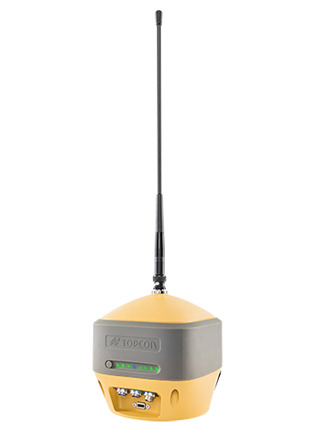
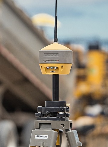
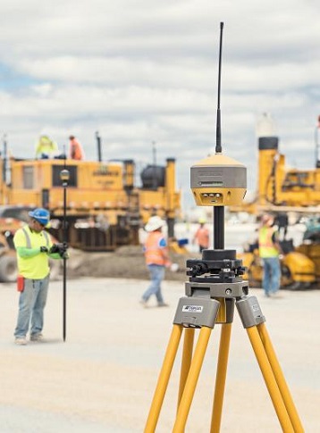
Topcon HiPer HR
Topcon creates the ultimate GNSS receiver
Compact, rugged and advanced, the Hiper HR is the right receiver for a broad range of applications.
Set yourself free to work
The HiPer HR GNSS receiver overcomes field challenges with a unique blend of technologies. If you're under tree cover, or can't get the pole plumb, or need to range widely from your base, or you need superb accuracy, or work in wet conditions, or all of the above, you be free you to do your best work.
As part of the Elite Suite hybrid positioning solution, using network correction, mounted to a vehicle or grade checking with Millimeter GPS, or an almost countless number of applications, the HR combines the features to help you succeed.
- Next generation Fence Antenna for superior reception
- Rugged, waterproof IP67 environmental design
- Cellular, LongLink and Radio communications all integrated
- 452 Universal Tracking channels
- Unique 9-axis T.I.L.T. compensation
- Internal Wi-Fi and multi-spectrum Bluetooth
Topcon Inertial Leveling Technology (T.I.L.T.)
By combining a 9-axis inertial measurement unit (IMU), along with a digital compass, the HR can accurately compensate for up to 15º of tilt on the rod.
Now you can measure all the way to a building edge without using an offset. Or stretch to get an otherwise out-of-reach point.
Just as with many other Topcon technologies, T.I.L.T. is designed to solve real-world challenges, so your work gets easier, faster, and better.
GNSS Tracking
- Number of Channels: 452 with patented Universal
- Number of Channels 2: Tracking Channel Technology
- Number of Channels 3: GPS, GLONASS, Galiileo,
- Number of Channels 4: BeiDou, QZSS, SBAS, L-Band
- Satellites Tracked: All in view
Accuracy
- Fast Static (L1+L2): H: 3 mm + 0.1 ppm
- Fast Static (L1+L2) 2: V: 3.5 mm + 0.4 ppm
- RTK (L1+L2): H:5mm+0.5ppm
- RTK (L1+L2) 2: V:10mm+0.8ppm
- Update/Output rate: Up to 100 Hz
Communications
- Radio: UHF(410-470MHz) SS (915 MHz)
- LongLink: Yes
- I/O Communications: Internal Cell modem Wi-Fi Bluetooth®
- Memory/Data Storage: Up to 32 GB
Power and Electrical
- Power: External power 6to28VDC
- Power 2: 2 x Internal batteries
- Power 3: 3.7 V, 2900 mAh each
- Operation Time: Up to 9 hours with
- Operation Time 2: removable batteries
Physical and Environmental
- Operating Temperature: Operating Temperature
- Waterproof: IP67
- Drop Test: 2 meter pole-drop
- Weight: 1kg
Product Downloads Section
Topcon Hiper HR
Topcon Hiper HR - Multi-Purpose GNSS Receiver
Topcon HiPer HR
Please contact us for more details on product rental.
Free Call: 0800-867-266
Phone: +64-9-476-5151
Email: info@synergypositioning.co.nz