
Products
- Machine Control
- GNSS Equipment
- Total Stations
- Lasers and Levels
- Aerial Mapping Systems
- Measuring Instruments
- Software
- Field Controllers
- Topcon Laser Scanning
- FARO Laser Scanning
- Mobile Mapping
- Hydrographic Survey Equipment
- Survey Accessories
- Lighting Systems
Your enquiry
Your rental enquiry
- Home
- Products
- GNSS Equipment
- GNSS Receivers
- Survey Receivers
- Topcon HiPer SR
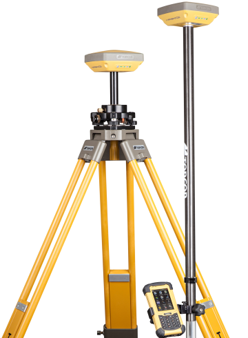
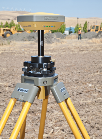
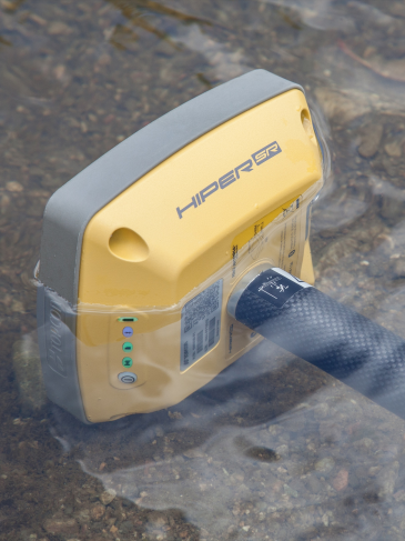
Topcon HiPer SR
Ultra Compact GNSS Receiver
Topcon's premier GNSS receiver in a smart, compact, ultra-rugged GNSS receiver. Lightweight yet tough enough to survive a 2m drop, and enough rechargeable batter for 20 consecutive hours of operation! Topcon's HiPer SR integrated receiver operates cable free, with no antennas, battery doors, or connectors. HiPer SR features the 226 channel, universal tracking capable Vanguard chip for unmatched performance flexibility to meet the needs for all jobs, large or small. Use a single SR for fast and accurate static GNSS or as a network RTK by adding network functionality and cellular enabled controller. Use a pair for an economical base and rover RTK solution or with Topcon's LongLink communication solution for the perfect small site-wide solution. The best part? There's a HiPer SR to fit your budget.
Power. Performance. Price. With the HiPer SR, it all fits in the palm of your hand.
Features Include:
- Vanguard chip technology featuring 226 Channels with Universal Tracking.
- Compact, lightweight, rugged design.
- Completely integrated receiver, antenna, batteries, memory, and communications.
- Integrated multi-channel LongLink™ communication technology.
- Sealed battery providing up to 20 hours of operation.
- 4GB onboard memory (Firmware limit of 2Gb for static data).
- Reduced MINTER display, with single-button operation.
- Charging (serial and power) and USB ports only.

Tracking
- Number of Channels: 226 Channels Vanguard Technology
- Antenna Type: Integrated Antenna w/ internal ground plane
- Technology: Quartz Lock Loop, Tracking Optimization
Signals Tracked
- GPS: L1 C/A, L1, L2P(Y), L2, L2C code &carrier
- GLONASS: L1 C/A, L1P, L2 C/A, L2P code & carrier
- SBAS : (WAAS/EGNOS/MSAS) L1 code & carrier
- QZSS: L1 code and carrier
Positioning Accuracy
- RTK (L1+L2): H:10 mm+1.0 ppm; V:15 mm+1.0 ppm
- DGPS: < 0.4 m
- SBAS: < 0.6 m
- Autonomous: < 1.2 m
- Maximum Data Rate: 20 Hz
Static
- Fast Static (L1): H:3 mm+0.8 ppm; V:4 mm+1.0 ppm
- Fast Static (L1+L2): H:3 mm+0.5 ppm; V:5 mm+0.5 ppm
- Kinematic (L1, L1+L2): H:10 mm+1.0 ppm; V:15 mm+1.0 ppm
Communication
- RTK Broadcast: LongLinkTM 300m+ Range
- Bluetooth®: Yes
- Serial: Yes
- USB: Yes, Client
Data & Memory
- Memory: 4GB internal (non-removable)
- Real Time Data Output: TPS, RTCM SC104 v 2.x, 3.x; CMR/CMR+
- ASCII Output: NMEA 0183 version 2.x and 3.0
Physical
- Dimensions: 150 (W) x 150 (D) x 64 (H) mm
- Weight: 850 gms, 1.87lbs
- Status Display / Panel: MINTER
- External Power Connector: Yes
Power Supply
- Operation Time: Up to 20 hours
Environmental
- Storage temperature: -40ºC to +70ºC
- Humidity: 100%, condensing
- Water & Dustproof rating: IP67
Operating temperature
- With Internal Batteries: -20ºC to +65ºC
- Without Internal Batteries: -40ºC to +65ºC (external power)
Product Downloads Section
HiPer SR Product Video
Power. Performance. Price. With the HiPer SR, it all fits in the palm of your hand.
Topcon HiPer SR Survey
Topcon's premier GNSS receiver in a smart, compact, ultra-rugged GNSS receiver. Lightweight yet tough enough to survive a 2m drop, and enough rechargeable batter for 20 consecutive hours of operation! Topcon's HiPer SR integrated receiver operates cable free, with no antennas, battery doors, or connectors. HiPer SR features the 226 channel, universal tracking capable Vanguard chip for unmatched performance flexibility to meet the needs for all jobs, large or small. Use a single SR for fast and accurate static GNSS or as a network RTK by adding network functionality and cellular enabled controller. Use a pair for an economical base and rover RTK solution or with Topcon's LongLink communication solution for the perfect small site-wide solution. The best part? There's a HiPer SR to fit your budget.
Power. Performance. Price. With the HiPer SR, it all fits in the palm of your hand.
- Day $295 NZD
- Week $1200 NZD
- Month $3300 NZD