
Products
- Machine Control
- GNSS Equipment
- Total Stations
- Lasers and Levels
- Aerial Mapping Systems
- Measuring Instruments
- Software
- Field Controllers
- Topcon Laser Scanning
- FARO Laser Scanning
- Mobile Mapping
- Hydrographic Survey Equipment
- Survey Accessories
- Lighting Systems
Your enquiry
Your rental enquiry
- Home
- Products
- FARO Laser Scanning
- Faro Software
- FARO VirtuSurv 2018
FARO VirtuSurv 2018

The new release features internal changes that will enhance your overall experience using VirtuSurv.
With Support for all AutoCAD® 2019 based Autodesk® products, BricsCAD versions 14 to 18 64-bit, SEMA version 15 (for timber construction), and many more. The latest update providing enhanced tools for evaluating laser scan data with or without CAD.
Technical Requirements
- Operating system: Windows 7 (SP1), Windows 8; Windows 10, 64-bit only.
- Hardware-requirements 1: Computer: Processor at least 2,5 GHz better 3-4 GHz
- Hardware-requirements 2: RAM at least 8GB better 32GB and more
- Hardware-requirements 3: Laser scanner: type according to task.
- Data requirements: Registered, i.e. scans with station information that have been oriented and geo-referenced to each other.
- Supported point cloud exports: LAS, PTS and kubit PTC.
- Supported scan data formats: FARO (FLS, FWS, LSPROJ), Standard-Format E57, Leica (PTG), Topcon (CLR, CL3), PTX.
- Supported CAD packages 1: All Windows applications, direct interfaces AutoCAD(LT), BricsCAD, SEMA.
- Supported CAD packages 2: Via the generic Windows interface: Rhino, GStarCAD, IntelliCAD, Cadwork, Trimble Business Center, Draft- Sight, AViCAD, Carlson, ZWCAD, MapScenes and many more
- Supported CAD packages 3: Via Field Book: Geograf, Covadis etc.
Product Downloads Section
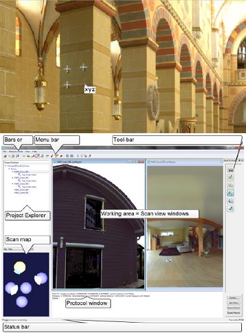
VirtuSurv Overview
In this 4-minute video, you get insight of FARO’s VirtuSurv intuitive high-speed evaluation of laser scan data, with examples of creating CAD drawings from scan data, creating floor plans in AutoCAD and AutoCAD LT, and creating facade plans in GstarCAD. Creating Field Books, filling in forms, tables or databases with measurements from the scans.